
Historical and Current Ecology of the Lower Passaic River
by Timothy J. Iannuzzi and David F. Ludwig
BBL Sciences, 326 First St., Suite 200, Annapolis, MD 21403
Abstract
The lower portion of the Passaic River (the river) is a tributary leading to Newark Bay and part of the New York–New Jersey Harbor estuary. The river is part of a highly urbanized ecosystem that has been severely degraded by more than 200 years of urbanization and industrialization. We conducted multiseason studies in 1999 and 2000 to characterize the present ecology of the river. These included detailed habitat profiles and surveys of benthic invertebrate, fish, and bird communities. In addition, we completed a detailed environmental-history study chronicling changes in ecology and human use in the lower Passaic River and the adjacent meadowlands habitats from pre-Columbian times to the present. Nearly all of the wetland and tidal tributary habitats that were once associated with the river have been removed by land-reclamation activities. In addition, water and sediment quality in the Passaic River were severely degraded in the late 19th and early 20th centuries due to industrial and municipal waste disposal associated with population growth and the industrial revolution in the Newark, New Jersey, metropolitan area. Current invertebrate and fish communities are not particularly diverse relative to other areas in the New York–New Jersey Harbor estuary and are dominated by pollution-tolerant organisms such as tubificid worms, mummichog (Fundulus heteroclitis), blue crab (Callinectes sapidus), and white perch (Morone americana). Similarly, bird use of the river is relatively low compared with other estuarine areas of New Jersey.
Key Words: Passaic River, Newark, New Jersey, habitats, benthic invertebrates, fish, birds, historical ecology
Introduction
Figure 1. Lower Passaic River, New Jersey
The lower Passaic River (the river) in New Jersey (Figure 1) is a tributary leading to Newark Bay and part of the New York–New Jersey (NY–NJ) Harbor estuary. The river is part of a highly urbanized landscape that has been severely degraded since the time of European settlement in the early 1700s. The river is tidal throughout the 17-mile stretch from its confluence with Newark Bay upstream to the Dundee Dam in Garfield, New Jersey.
The story of the lower Passaic is one of a highly industrialized river. Once a rich ecosystem inhabited by a diverse and abundant community of invertebrates and vertebrates, the river has suffered severe deleterious effects from more than 200 years of industrialization and urbanization. Nearly all of the wetland and tidal-creek habitats once present have been destroyed by land-reclamation activities (Table 1). In addition, water and sediment quality in the river were severely degraded in the late 19th and early 20th centuries by industrial and municipal waste disposal associated with population growth and the industrial revolution in the Newark, New Jersey, metropolitan area. These conditions have steadily improved since the passage of the federal Clean Water Act in 1970. However, given the large human population of the region and the high density of industrial facilities lining its shores, the Passaic continues to be one of the most polluted rivers in the United States. Iannuzzi et al. (2002) provide a detailed description of the historical uses of the river and the associated impacts from pre-Columbian times to the 1990s.
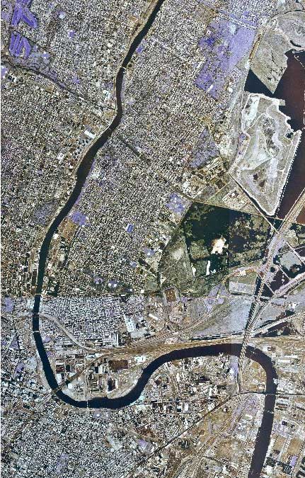
Figure 2. Passaic River Landscape
Land-use patterns adjacent to the lower Passaic River are illustrated in Figure 2. The surrounding urban landscape has a tremendous influence on the extent and quality of the habitats in the river itself. The few remaining habitats are for the most part fragmented and degraded. This, in turn, has a great effect on the types and abundance of plant and animal communities that the lower Passaic River can support.
In this paper, we summarize historical ecological information on the lower Passaic River and present data and other information from habitat and biological surveys conducted in 1999 and 2000 as part of ongoing investigations conducted by the United States Environmental Protection Agency and other government agencies and private parties under the Comprehensive Environmental Response, Compensation, and Liability Act. The objective of this study is to combine historical information with the recently collected data to show ecosystem alterations in this intensely urbanized waterway. We believe that an understanding of both the historical and current conditions is necessary not only to help determine causes of the present ecological conditions in the lower Passaic but also to help define the potential scope for restoration of the river.
Methods
This section summarizes the methods we used to compile data and information on the ecology of the lower Passaic River.
Habitat Characterization
Habitat studies were undertaken in the late summer of 1999 and again in the spring of 2000. Our objectives were to document, quantify, and characterize the location and extent of available aquatic, wetland, and terrestrial habitats in the lower Passaic River. We used remote sensing and direct observation to quantify the present distribution of habitats. To document the distribution of shoreline habitat types, we analyzed aerial photographs and videotapes (aligned with Global Positioning System location records taken simultaneously) of the entire study area. The videotapes (which provide the greatest spatial resolution) were checked against the aerial photography and extensive direct observation.
We also did archival research to evaluate changes in habitat conditions over time. Maps and other records provided quantitative documentation of the nature and extent of key components of the estuarine habitat complex (wetlands, drainage tributaries, aquatic/terrestrial ecotones) of the lower Passaic River from presettlement to the present. We compiled the available information, did the systematic calculations necessary to make the data comparable and uniform in spatial and temporal terms, and prepared synoptic maps illustrating the habitat changes. Much of this information is presented in detail in Iannuzzi et al. (2002).
Benthic Invertebrate Community Surveys
Benthic invertebrate community surveys were conducted in the fall of 1999 and spring of 2000. We collected three surface-sediment samples from each of 15 stations throughout the lower Passaic River during the fall of 1999 and from 14 stations in the spring of 2000. A Petite Ponar grab sampler was used to collect the samples. The samples were sieved and sorted, and invertebrates were identified to the lowest practicable taxon. We analyzed the resulting data for various measures of community diversity and abundance.
Similar community surveys were conducted during the same time frames in the Mullica River, a tidal tributary leading to Great Bay in southern New Jersey, which we used as a relatively nonpolluted reference area for some of the lower Passaic River studies, including the benthic invertebrate community survey. Three surface-sediment samples were collected and analyzed (as described above) from each of three stations throughout the lower Mullica River during each of the two seasonal samplings. The data from the lower Passaic and Mullica rivers are compared in this study.
Fish and Blue Crab Community Surveys
Fish and blue crab community surveys were also conducted in the fall of 1999 and spring of 2000. For these surveys, we divided the lower river into upper, middle, and lower sections. Fish and blue crab of various sizes and life stages were captured using a variety of gear, including gill nets, baited crab pots, eel pots, and minnow traps. This variety of gear types was selected to maximize the number of species captured in the various habitats and depths of the river. Sampling was confined to areas outside the main navigation channel, in accordance with United States Coast Guard requirements.
We deployed each gear type in each sampling section of the lower river on a daily basis for about two weeks during each season. Captured fish were identified, weighed to the nearest gram,* and measured to the nearest millimeter. The resulting data were compiled and analyzed to provide estimates of catch per unit effort, diversity, abundance, and dominance. A list of the fish caught during the fall 1999 and spring 2000 surveys is in Table 2.
Bird Community Surveys
We conducted bird surveys for one year, beginning in the fall of 1999 and ending in the summer of 2000. Four seasonal surveys (spring, summer, autumn, and winter) were done. Each survey included multiple counts of all birds observed on mudflats, along the shoreline, and on bridge abutments. Spring, summer, and fall surveys included counts taken at both low and high tides, in the morning, at midday, and at dusk, thus incorporating the range of expected bird activity periods (morning and evening low tides normally being the periods of highest activity, and midday high tides the time of minimum activity). The winter survey was a one-day effort encompassing morning and evening low tides and midday high tide. Each survey included an estimate of the number of gulls flying over a defined "volume" of space at the central portion of each bird survey area, in addition to total counts of perched, swimming, and foraging birds. The bird survey was conducted using methods provided in Bibby, Burgess, and Hill (1992), as described in Ludwig and Iannuzzi (2002).
The results of the seasonal bird surveys were compiled and analyzed for various patterns of diversity, abundance, and habitat use. To the extent possible, these data were compared with other reported bird diversity and abundance data from nearby areas and along the New Jersey coast. A summary of the birds observed during the 1999–2000 surveys is in Table 3.
Results and Discussion
Habitats
Figure 3. A Comparison of the Extent of Wetlands in Lower Passaic River Environs: Early 1800s and Today
The majority of wetlands and associated habitats once present in the lower Passaic River are now gone (Figure 3). These were altered or removed by land "reclamation" activities and mosquito ditching. Most notably, a long stretch of the south shore of the lower Passaic River was once a large intertidal salt marsh and likely a key habitat in this ecosystem. Between 1873 and 1890, this area was covered with 8 to 12 feet of mixed fill material from coal gasification facilities, eliminating the marsh habitat (Iannuzzi et al., 2002). In addition, more than 25.1 miles of tributaries leading to the lower Passaic environs were lost (Table 1). This loss of wetland and tidal-creek habitats had a substantial impact on the biological productivity of the lower Passaic River.
In addition, dredging caused major disruption of the river bottom between 1874 and 1983. This, combined with bridge construction, commercial shipping, and municipal and industrial pollution, had a substantial adverse impact on the benthic communities of the lower Passaic River.
The remaining habitats are limited primarily to degraded intertidal mudflats and subtidal bottom. There are a number of small patches of vegetated wetland scattered throughout the lower Passaic River. These are dominated by Phragmites australis (common reed), although Spartina alterniflora (saltmarsh cordgrass) and other species are also present. The total area of vegetated wetlands along the first six miles of shoreline in the lower Passaic River is less than one acre.
All of the historical natural shoreline of the lower Passaic River has been substantially modified. Today, the shoreline is highly industrialized and abutted along much of its length by buildings and parking lots. In a few areas, corridors of weedy vegetation line the shore. These remnant riparian communities are dominated by Phragmites australis in low-lying areas adjacent to the water or mudflats and by mixed tree and scrub-shrub communities at higher elevations. Ruderal species, including Ailanthus altissima (tree of heaven), Artemisia species, and Solidago species (goldenrods) dominate.
Using data collected during the 1999 and 2000 surveys, we categorized the lower six miles of Passaic River shorelines as bulkhead, riprap, mixed vegetation, or aquatic vegetation. Bulkhead consists of horizontal or vertical wood timbers, metal sheet pile, or large stone blocks constructed to form a vertical face perpendicular to the water surface. Riprap includes cobble- to boulder-size stone and/or concrete rubble placed along the shoreline on a sloped bank. Mixed vegetation refers either to areas with aquatic/riparian vegetation interspersed with bulkhead and/or riprap or areas of riprap with substantial overhanging riparian vegetation. Aquatic vegetation refers to areas with emergent wetland plant species such as Spartina alterniflora or Phragmites australis. These categories distinguish between weedy, disturbed shoreline areas with upland vegetation (mixed vegetation) and areas that are clearly wetlands (aquatic vegetation).
The number of linear feet of each shoreline category is presented in Table 4. Most of the shoreline in the lower Passaic River (82%) consists of bulkhead (52%) and riprap (30%). These are used to stabilize the shoreline and protect the industrial and urban properties that line the river's banks. While riprap can provide refuge for some organisms, its habitat quality, particularly in low-salinity areas like the lower Passaic River, is minimal. Bulkheads, which are typically built using either metal sheet piling or pressure-treated wood, have no habitat value and reduce the value of adjoining habitats. The prevalence of bulkhead and riprap along its shorelines is a substantial limitation to the ecology of the lower Passaic River.
About 12% of the total lower Passaic River shoreline is composed of mixed vegetation areas. Only about 6% supports any kind of wetlands. The latter is divided almost equally between small patches of Phragmites and Spartina. The mixed vegetation areas are interspersed with riprap shoreline or are adjacent to mudflats where the elevation grades above the high-tide line. The low percentages of vegetated shoreline areas and wetlands are clear indicators of the lack of foraging and cover habitat in the lower Passaic River, and therefore the constraints on its biological productivity.
The primary aquatic habitats are intertidal mudflats and subtidal bottom, 8% and 92%, respectively, of the lower Passaic River bottom area. The intertidal mudflats and their associated shallow-water subtidal areas are the most important habitats left for estuarine organisms, providing the only available foraging habitat for fish, blue crab, and waterbirds.
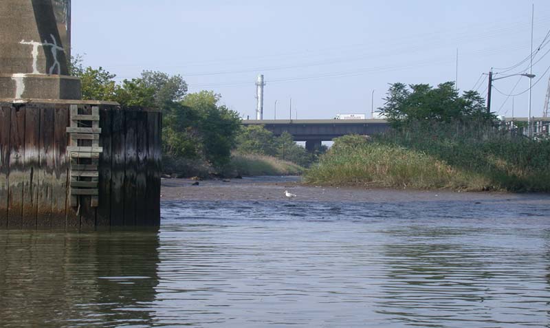
Figure 4. A Small Remnant Marsh Found at the Confluence of Lawyers Creek and the Passaic River

Figure 5. Worthington Avenue Combined Sewer Overflow Area
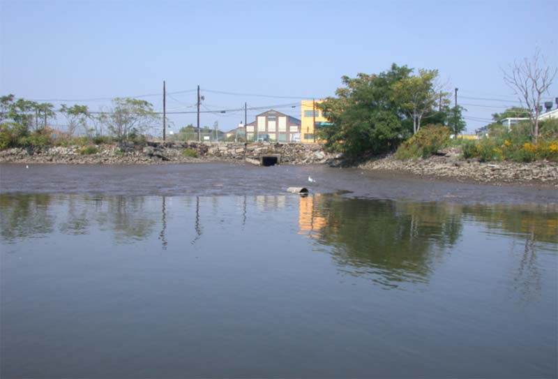
Figure 6. Large Mudflat System Adjacent to Unnamed Creek
Although wetland areas are small and patchy in the lower Passaic River, three such areas appear to be functional habitats supporting biological production. These are Lawyers Creek (approximate river mile 0.5) and the associated marshes near its confluence with the Passaic River (Figure 4); a small marsh remnant downstream of the Worthington Avenue combined sewer overflow (CSO) at approximately river mile 2.5 (Figure 5); and a small, unnamed creek remnant and adjacent shoreline area at approximately river mile 3.5 (Figure 6). These three areas each represent a small habitat complex.
Lawyers Creek is one of the few historical tidal creeks that remain in the lower Passaic River, albeit substantially altered and reduced in size from its original configuration. The confluence of Lawyers Creek and the Passaic River contains a large expanse of mudflat and a Phragmites marsh, with some Spartina fringing the Phragmites stand. The creek and its associated wetland complex provide refuge and possibly spawning habitat for aquatic organisms and wading birds.
The Worthington Avenue CSO area is a small cove that supports wetland vegetation (Phragmites and Spartina) and an unvegetated intertidal flat. The stand of intertidal wetland provides cover and possibly spawning habitat for a variety of estuarine organisms.
The creek remnant at river mile 5.3 supports a small habitat complex including intertidal mudflat, artificial hard-bottom substrate, and upland vegetation. The habitat heterogeneity makes this a unique site in the lower Passaic River. In addition, this area is contiguous with one of the larger and more ecologically valuable mudflats in the lower river.
Benthic Invertebrate Communities
No quantitative studies of the benthic community in the lower Passaic River, either pre- or post-industrialization, are available in the historical literature. However, based on the habitat characterization and the history of sediment degradation, it can be inferred that the benthic communities of the lower Passaic River have suffered adverse effects since at least the mid-19th century. It is also likely that the sewage and industrial and municipal wastes dumped into the river through the mid-20th century limited the benthic communities. Another major impact was the dredging of large stretches of the river throughout most of the 20th century.
Since passage of the federal Clean Water Act of 1970, waste disposal in the river has decreased substantially, and water and sediment quality has improved considerably. While municipal and industrial wastes continue to be discharged into the river through CSOs and storm-water drains, water and sediment are cleaner now than they have been for decades. In addition, the river has not been dredged since 1983. Thus, it is likely that benthic communities are more robust now than they have been for years.
Using the fall 1999 and spring 2000 data sets for the lower Passaic River and the Mullica River reference area, we characterized the benthic communities. Figures 7, 8, 9, and 10 include selected measures of the structure and composition of the benthic invertebrate communities in the lower Passaic River and the reference area. Bars in these figures represent the maximum and minimum numbers of individuals, and the symbols within the bars represent the averages. The results of the surveys indicate that the lower Passaic River benthic communities are somewhat variable in structure and composition. We found a tendency toward greater abundance of invertebrates in the lower Passaic than in the Mullica, a result of large numbers of tubificid worms in several of the Passaic samples (Figure 7). The average number of taxa per sample in each of the two rivers is generally similar (Figure 8).
Figure 7. Benthic Invertebrate Community Assessment: Number of Individuals

Figure 8. Benthic Invertebrate Community Assessment: Number of Taxa
Lower Passaic River benthic communities are composed primarily of pollution-tolerant organisms from a variety of functional feeding groups (Figure 9). Few pollution-sensitive species (e.g., crustaceans) were found in the lower Passaic River, compared with the Mullica (Figure 10). In general, habitat does not appear to control benthic community structure in the Passaic, as bottom conditions, including grain size and organic carbon content of the sediments, don't vary greatly among sites.
Figure 9. Pollution Tolerance of Benthic Invertebrates

Figure 10. Benthic Invertebrate Community Assessment: Percent Abundance of Crustacea
We developed a qualitative classification system for the benthos based on a comparison of various measures of community structure in the lower Passaic River relative to those in the Mullica River. Based on this system, each measure in the lower Passaic River was scored as "excellent," "good," or "poor." This approach is similar in some ways to that described by Deshon (1995) for comparing invertebrate community indices (ICIs) within river stretches of various watersheds. The results (Figure 11) suggest that the quality of the benthic communities in the lower Passaic River varies among sites, ranging from diverse to quite depauperate (i.e., species-poor). This finding is typical of the heterogeneous nature of infaunal communities in estuaries, reflecting the patchy distribution of benthic species in this kind of ecosystem.
Figure 11. Benthic Invertebrate Community Condition
Fish and Shellfish Communities
Overharvesting, loss of habitat, and pollution have had a substantial impact on fish and shellfish populations in the lower Passaic River and surrounding environs (Iannuzzi et al., 2002). Tidal creeks and wetlands provide vital nursery and foraging habitat for these organisms, and it is likely that the historical losses of these habitats in the lower Passaic River have resulted in a fishery substantially reduced from preindustrial levels. Historical documentation of fish and shellfish communities in the Passaic River is limited from both a spatial and temporal standpoint and is largely qualitative in nature. The fish and crustacean community surveys we conducted in 1999 and 2000 were the most detailed and quantitative fisheries surveys conducted in the lower portion of the Passaic River to date.
Historical fish and shellfish harvests in the lower Passaic River included striped bass (Morone saxatilis), rainbow smelt (Osmerus mordax), American shad (Alosa sapidissima), sturgeon (Acipenser species), perch (family Percidae), and a number of freshwater fish species, as well as American oysters (Crassostrea virginiana) and various clams, shrimp, and crabs (Iannuzzi et al., 2002). Steady declines in the fish and shellfish harvests occurred during the late 1800s due to a number of factors, including chronic sewage pollution, low dissolved oxygen (DO) levels, toxic levels of various petroleum hydrocarbon and metals contaminants, habitat destruction from shoreline modification and wetlands loss, and dredging activities (Steimle & Caracciolo-Ward, 1989). By the early 1900s, commercial harvests of fish and shellfish from the Passaic River had ceased (Iannuzzi et al., 2002). A February 1897 Passaic Valley Sewerage Commission (PVSC) report on sewage disposal revealed that fish life, except for a few hardy species, had disappeared from the Passaic River prior to the turn of the 20th century (PVSC, 1897).
Only anecdotal information exists on the Passaic River fishery during the mid-1900s. There was little interest in investigation—few fish were present, as habitat destruction and sewage and contaminant pollution had severely limited the river's ability to support most of the species that once inhabited it. In addition, there was little human access to the lower Passaic River and limited recreational use, since industry dominated the shoreline (Iannuzzi et al., 2002).
Some recovery of the fishery occurred in the early 1970s following the authorization and implementation of the Clean Water Act. Several species returned to the river in limited numbers, including anadromous fish such as American shad and river herring. With the onset of federal and state environmental regulations beginning in the 1970s, there was a new focus on improving the water quality of America's rivers, including the Passaic. As a result, scientists and regulators began to study the fishery of the river and provide the first quantitative documentation of its condition. Water-quality tests conducted as part of the New Jersey Bureau of Freshwater Fisheries study (NJBFF, 1981) indicated that levels of DO were critically low in much of the water column of the lower Passaic River. Dissolved oxygen is still limiting on a seasonal basis. Low DO remains a physical impediment to fish and crustacean communities in the river today, and it limits the ability of many fish to survive in affected portions of the water column, at least in the summer. It also impedes migrating fish attempting to reach spawning areas of the river and its tributaries.
Figure 12. The Current Fishery of the Lower Passaic River
A total of 22 fish species and blue crab were captured in the lower Passaic River during the 1999 and 2000 community surveys (Table 2). Sixteen fish species were captured in the fall 1999 survey and 12 species in the spring 2000 survey. Six species made up 98% of the total catch from the two surveys (Figure 12). The mummichog (Fundulus heteroclitis), a small forage fish that is very common in East Coast estuaries, composed more than 75% of the total catch. Other dominant species included inland silverside (Menidia beryllina), white perch (Morone americana), Atlantic menhaden (Brevoortia tyrannus), striped bass, and gizzard shad (Dorosoma cepedianum). The only resident species in this group are the mummichog and white perch. The remaining four species are migratory and typically occur in the lower Passaic River from late spring to early fall (which is why many were captured in both of the surveys).
Resident and migratory species of the lower Passaic River are listed in Table 3. Resident species are found throughout the year. Migrant species occur seasonally. Rare or exotic species are not common in the Passaic River, but they may enter its waters during periods of drought (when water salinity is higher) or during periods of significant rain events (when water salinity is lower). Several functional feeding groups are represented in the fish community, including detritivores (e.g., common carp), piscivores (e.g., striped bass, bluefish), and omnivores (e.g., mummichog, white perch).
Overall, the diversity and abundance of fishes in the lower Passaic River is low relative to species reported in other greater New York–New Jersey area estuaries (see Iannuzzi et al., 2002) and historical reports for the lower Passaic River itself. This is likely due to the continued combined effects of habitat limitations and poor water and sediment quality.
Bird Communities
Like fish and invertebrates, birds have been adversely affected by industrialization and urbanization and associated habitat losses and degradation in the lower Passaic River. Historically, the NY–NJ Harbor estuary has been a focal point for migration, important for both land birds and many kinds of waterbirds (Shriner, 1896; Leck, 1984; Iannuzzi et al., 2002). The highly urbanized nature of the present landscape has important consequences for the bird fauna. Ecological resources are depauperate in urban settings (Gill & Bonnett, 1973), and bird populations and communities in the NY–NJ Harbor estuary area reflect the general trend of decreasing bird diversity with increasing urbanization (Barrett, 1990).
The effect of urbanization on habitats is graphically illustrated in Figure 2. This aerial photograph shows the intensely developed landscape of the lower Passaic River. With the exception of scattered remnants of open space (all subject to more or less intense human disturbance), the entire area consists of buildings and impervious surfaces. The same is true throughout much of the Newark Bay region. The few remaining fragments of green space provide little habitat for diverse bird communities and essentially no habitat for aquatic bird species.
Dominant habitat types in the lower Passaic River are all urban in nature, and available intertidal foraging areas for birds are limited to the isolated intertidal flats. These flats represent the only truly functional habitat for aquatic birds in the lower Passaic River. Many of the flats border vertical upland, bulkhead, or riprap shoreline or are near bridges and roadways and therefore have reduced foraging value for some waterbird species (Kane, Kerlinger & Radis, 1991). The few flats that front patches of wetland have greater value as foraging habitat for aquatic birds, although they represent a relatively small area and are spatially isolated.
A quantitative answer to the larger question, how does urbanization affect bird community structure? would require comparative observations of bird use of the lower Passaic River and a similar but less urbanized river system. Such a quantitative survey has yet to be conducted, so a complete answer to the question is not possible at the present time. However, a qualitative, partial answer can be obtained by evaluating available information on birds in the region.
Figure 13. Relative Waterbird Use of Lower Passaic River
One approach to answering this question is to use breeding bird survey data published in Walsh, Elia, Kane, and Halliwell (1999). Survey blocks in the lower Passaic and Hackensack river systems can be compared based on the general availability of open land and wetland habitat. It would be expected that survey blocks with greater open and/or wetland areas would support a higher diversity of breeding birds. This does appear to be the case. Figure 13 shows the number of breeding bird species reported by survey block in the lower Passaic-Hackensack river area. All blocks with a substantial remaining component of wetland habitat (either Hackensack Meadowlands or Kearny Marsh, the latter within the Passaic River watershed but not connected at the surface) have a substantially greater diversity of breeding birds than the single block of lower Passaic River habitat without wetlands. It may be concluded that the relative lack of open space and/or wetlands does indeed constrain breeding bird diversity in the lower Passaic River.
A second approach is to compare the number of foraging bird species per unit area and the density of individuals between similar habitats on the Passaic River and in a less urbanized setting elsewhere. An analysis provided by Hoden (1997) makes this second approach possible. The report includes observations of bird diversity and density on a small intertidal mudflat located in Great Bay near the town of Tuckerton (in the estuary of the Mullica River). These observations can be compared on a qualitative basis with similar data recorded during the bird survey of the lower Passaic River. Figure 14 presents this comparison. It is clear that, on a unit area basis, the urbanized ecosystem of the lower Passaic River supports a waterbird fauna depauperate in both individuals and species relative to that of the Great Bay system.
Figure 14. Waterbird Mudflat Use in Lower Passaic River and Great Bay
During the four seasonal surveys of the lower Passaic River in 1999 and 2000, 49 species of birds were observed (Table 3). This is a small fraction of the 443 species that have been recorded statewide or the 340 species that occur annually throughout the state (Walsh, Elia, Kane & Halliwell, 1999). Indeed, it is a small fraction of the 313 species that have been reported in the NY–NJ Harbor estuary. Of the 49 species observed during the lower Passaic River surveys, 19 are strictly terrestrial (including a single observation of an escaped domestic budgerigar). The remaining 30 species are primarily associated with aquatic ecosystems.
Gulls are by far the most abundant birds in the lower Passaic River, followed by common species of duck and bridge-nesting swallows. Among birds feeding at relatively high levels in the aquatic food web, the double-crested cormorant, herons, and egrets are most abundant. Key fish-eating birds (herons and egrets) are present in the lower Passaic River in spring, summer, and autumn only, as expected for such migratory species. The kingfisher, while not observed in winter, is likely present year-round (Walsh, Elia, Kane & Halliwell, 1999).
Conclusion
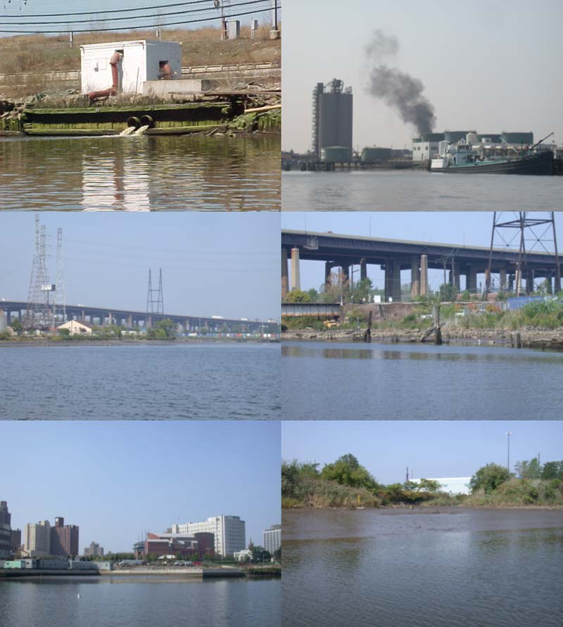
Figure 15. Urban Nature of Lower Passaic River
The lower Passaic River is an intensely urbanized ecosystem with severe constraints on plant and animal life (Figure 15). The diversity and abundance of many groups of organisms is low. While this may not be unexpected in a river draining this landscape (Figure 2), it is not inevitable. The depauperate nature of the biological communities is not attributable to a single cause. Habitat losses, non-point- and point-source pollutants, and ongoing human disturbance are all factors. Restoring some measure of ecological health to the lower Passaic River ecosystem will require amelioration of each constraint—a difficult, but achievable, goal.
*Except where noted, measurements throughout this paper are in metric notation; conversions to U.S. equivalents can be obtained at http://www.onlineconversion.com/