
The Meadowlands Before the Commission: Three Centuries of Human Use and Alteration of the Newark and Hackensack Meadows
by Stephen Marshall
P.O. Box 524, Lincoln Park, New Jersey 07035
Abstract
Human use and alteration have caused dramatic changes in the Newark and Hackensack meadows during the three centuries following European settlement of northeastern New Jersey. Human activities have historically fallen into four major categories: extraction of natural resources; alteration of water flow; reclamation, land making, and development; and pollution by sewage, refuse, and hazardous waste. By the time of the creation of the Hackensack Meadowlands Development Commission in 1969, the original 42-plus square miles of tidal and freshwater wetlands had been radically transformed. Tidal flow of saltwater extended much farther into the estuary's waterways, transforming previous freshwater portions of the wetlands into brackish and saltwater habitats. The southern third of the Meadowlands had been entirely developed, and the remainder was a patchwork of developed upland and undeveloped wetlands. Total wetland acreage had been reduced to about 13 square miles, much of it polluted by sewage and solid waste.
Key Words: estuary; garbage; Meadowlands; Hackensack River; land making; landfills; municipal water supply; Passaic River; pollution; reclamation; tidal wetlands.
Introduction
This paper provides an overview of the major types of human use and alteration of the Newark and Hackensack meadows, from the time of the first European settlements in the mid-1600s to the creation of the Hackensack Meadowlands Development Commission in the late 1960s.
Before European settlement the Newark and Hackensack meadows (also known as the Meadowlands, the Jersey Meadows, and the Newark and Hackensack Tidal Marsh) made up a large complex of tidal, brackish, and freshwater wetlands located in northeastern New Jersey. They surrounded most of the lower Hackensack River, bordered part of the lower Passaic River, and formed the western edge of Newark Bay.
The Newark Meadows and much of the Hackensack Meadows no longer exist. The official boundary of the present-day Hackensack Meadowlands, as defined in the 1968 Hackensack Meadowlands Development Act, encompasses approximately 32 square miles. It includes all or parts of 14 municipalities in Bergen and Hudson counties (Figure 1). Almost half the area of the officially defined Meadowlands has been transformed into dry upland, leaving slightly more than 13 square miles as wetlands (Figure 2). A large number of former open dumps and sanitary landfills are located in the Meadowlands (New Jersey Meadowlands Commission, 2002; New Jersey Meadowlands Commission, n.d.).
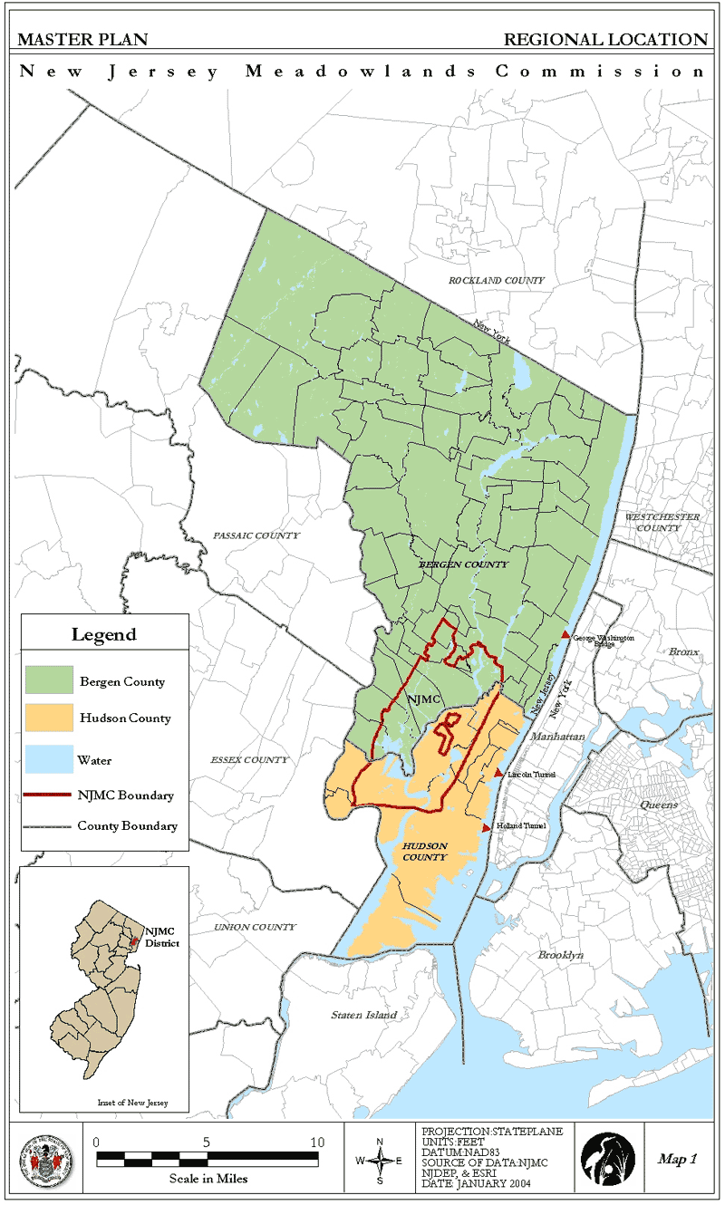
Figure 1: New Jersey Meadowlands Commission Regional Location Map
Photo Credit: New Jersey Meadowlands Commission
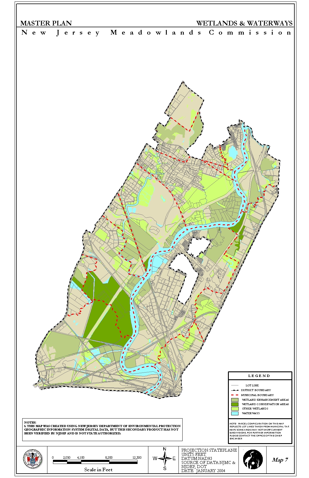
Figure 2: New Jersey Meadowlands Commission Wetlands Map
Photo Credit: New Jersey Meadowlands Commission
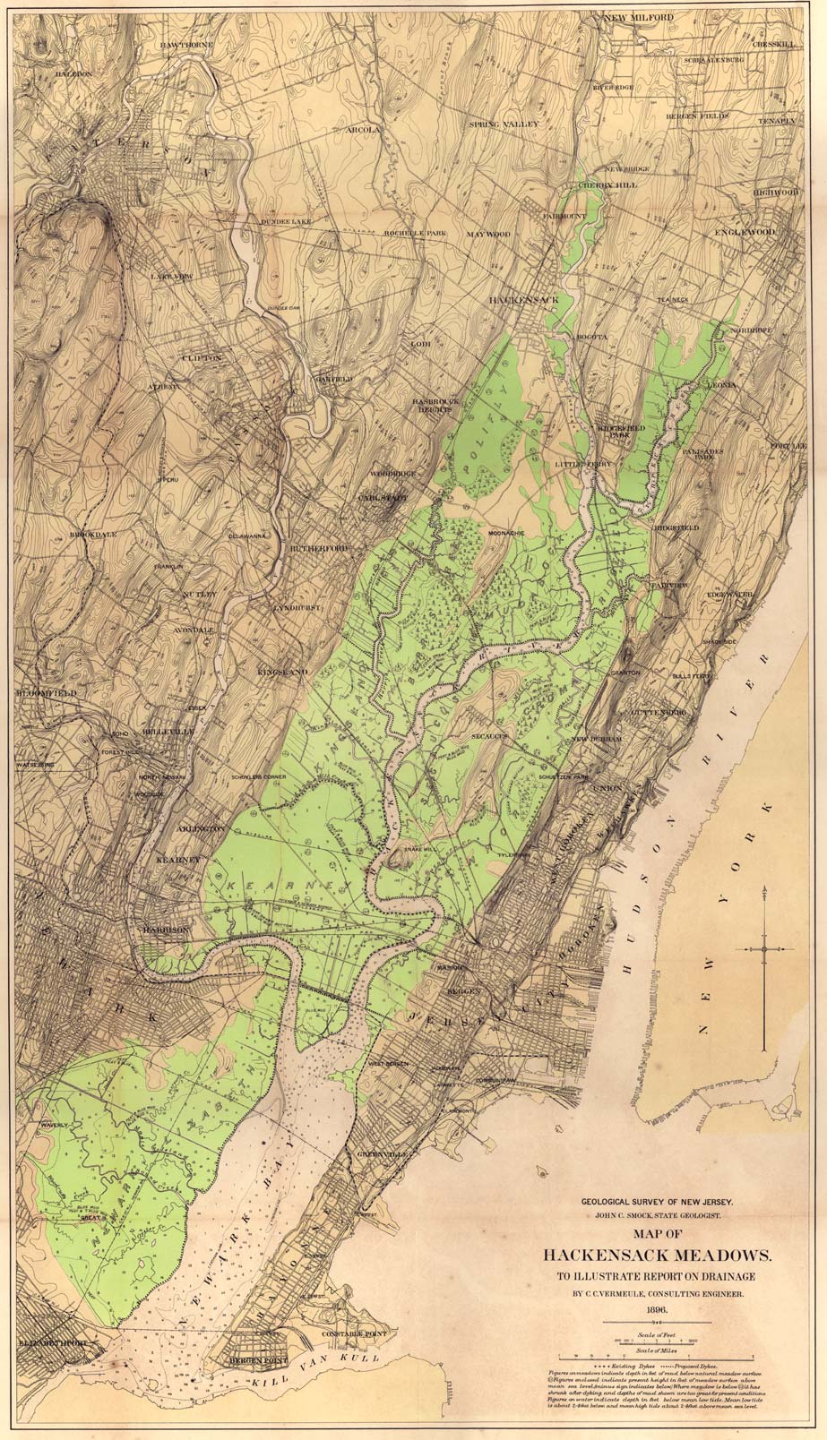
Figure 3: 1896 Map of Hackensack Meadows
Photo Credit: U.S. Fish and Wildlife Service
The present-day Meadowlands cover a much smaller area than in the past. An 1896 survey by the state geologist calculated the total acreage of the Newark and Hackensack meadows as slightly less than 43 square miles. The Meadowlands then extended north to Hackensack and south to Elizabeth (Figure 3). The southern portion of the Meadowlands, located on the west side of Newark Bay, was known as the Newark Meadows and has been entirely developed. These former wetlands are now covered by Port Newark/Elizabeth, Newark Liberty International Airport, the New Jersey Turnpike, and other urban infrastructure.
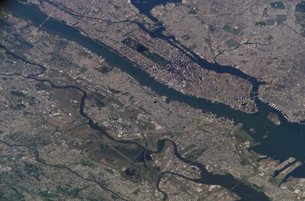
Figure 4: Satellite Image of the Meadowlands
Photo Credit: NASA
The Meadowlands are relatively well known, since they are within three miles of Manhattan and are bordered and crossed by several major transportation routes (Figure 4). Railroad facilities bordering or crossing the Meadowlands are used by New Jersey Transit and the Port Authority Trans-Hudson Line, as well as Conrail and other private railroad companies. Major highways include the New Jersey Turnpike, Interstate Highways 80 and 280, and New Jersey Highways (Routes) 3, 17, 46, and 120. Sports enthusiasts know of the Meadowlands Sports Complex, home of the New York Jets, New Jersey Nets, New Jersey Devils, New York Giants, and other teams. Additional public awareness has resulted from scenes of the Meadowlands in films such as Being John Malkovich (1999) and Broadway Danny Rose (1984), as well as in the opening credits of the television series The Sopranos (1999–). The Meadowlands have also been a favorite subject for artists, including George Inness and Martin Johnson Heade in the 19th century and, more recently, Herman Hartwich, Gary Godbee, and Tim Daly.
The creation of the Hackensack Meadowlands Development Commission (HMDC) in 1969 marked the start of a new era in the history of the Meadowlands, characterized by extensive government regulation. The enabling legislation gave the commission five goals, of which two were considered primary: facilitation of coordinated planning and development of the remaining wetlands, and regulation of garbage disposal. It was originally assigned only limited conservation goals. Within several years after its creation, however, the HMDC shifted its focus to the preservation of the remaining wetlands and the remediation of polluted or destroyed acreage (Ginman, 1968; Boldt, 1972; Goldman, 1975; Goldshore, 1976). The agency's revised mission was recently symbolized by the enactment of legislation in 2001 that changed its name to the New Jersey Meadowlands Commission.
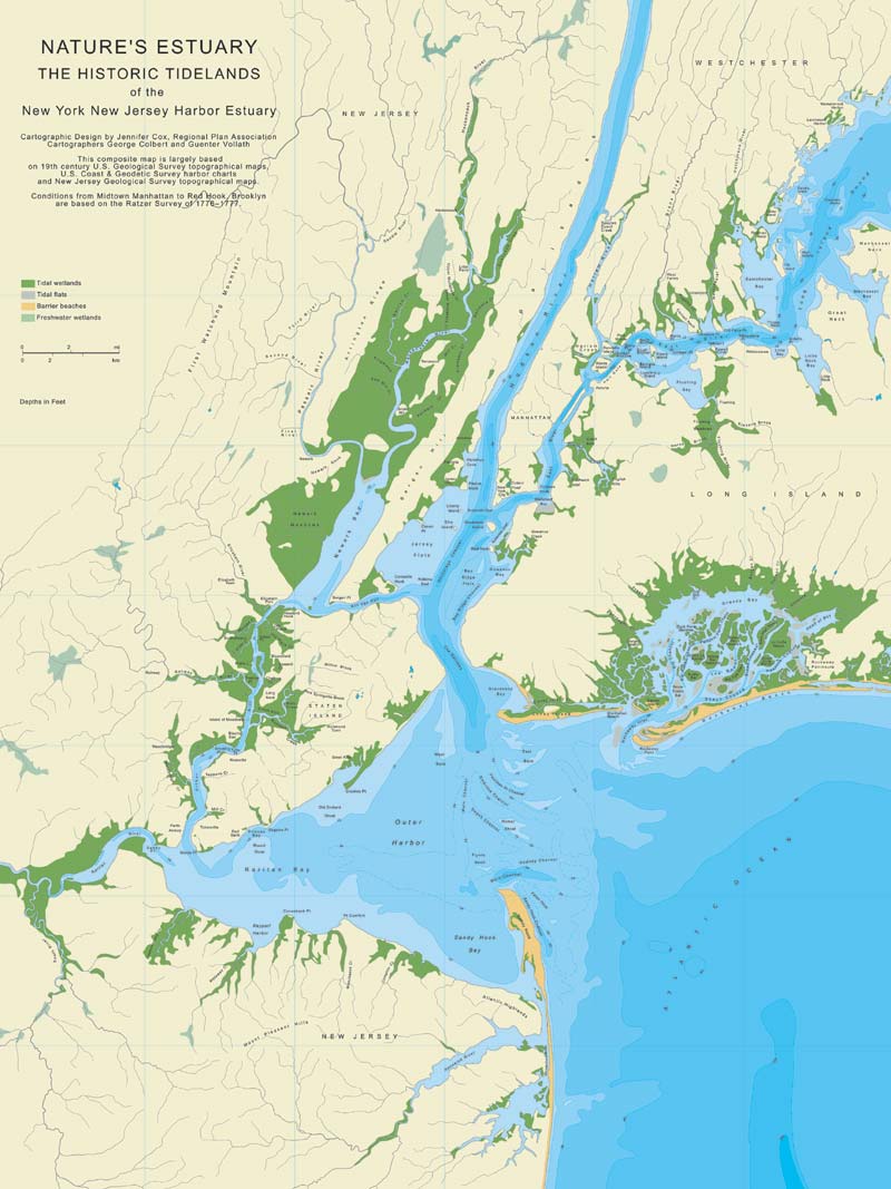
Figure 5: RPA Map: Nature's Estuary, the Historic Tidelands of the New York New Jersey Harbor Estuary
Photo Credit: Regional Plan Association, New York
Several excellent books describe the work of the HDMC and the recent history of the Meadowlands (Sullivan, 1998; Quinn, 1997). This paper focuses on the history of the Meadowlands during the 300 years before the creation of the HMDC. A study of this period reveals long-term trends that might be relevant to understanding the history of other present (and former) wetlands in the New York–New Jersey metropolitan region, such as Flushing Bay, Jamaica Bay, Newtown Creek, and Gowanus Canal (Figure 5).
Three Aspects of Environmental History
The primary aim of this paper is to describe the pattern of major human uses and alterations of the Newark and Hackensack meadows. A description of human impact on the environment, however, is not the only possible focus of environmental history. There are at least two other aspects of environmental history worth noting. Environmental historians Donald Worster and William Cronon have proposed using "three levels of analysis in environmental history." These include not only how human activities have modified the natural environment but also the political economy that caused these changes, as well as the prevailing beliefs and idea systems though which decisions and changes were interpreted (Cronon, 1990).
This section of the paper briefly addresses the two latter aspects of historical analysis. A study of the underlying political economy that encouraged (or prevented) various types of activities affecting wetlands shows a pattern of government involvement divided into two periods. The first period lasted from the 1660s to the early 1900s. During this time there was minimal use of government power regarding the wetlands. The government's role was primarily to 1) distribute title to the wetlands (and all other land in New Jersey) from the government to private individuals, and 2) set up a legal system whereby the owners could develop the land in any way they desired. Legal historian Willard Hurst described this process as "the release of energy" associated with early American capitalism. There were minimal restraints upon disposition of land: It could be easily purchased and easily sold. Society relied upon the market system for the optimal disposition of all land (including wetlands), which was simply treated as another form of private property (Hurst, 1956).
The second period began in the 20th century and was characterized by a more active government role. Public agencies, as well as private firms and individuals, acquired and developed portions of the Meadowlands. The Newark Meadows were developed almost entirely by government entities. The city of Newark initiated the construction of Port Newark in 1914 and Newark Airport in 1927. Two decades later, these projects were taken over and expanded by the Port of New York Authority (now called the Port Authority of New York and New Jersey) (Doig, 2000). In the late 1960s, the New Jersey Legislature created the HMDC (and the New Jersey Sports and Exposition Authority) to hasten development of the northern portion of the Meadowlands.
Analysis of the second major aspect of environmental history noted by Cronon and Worster—the set of prevailing public attitudes regarding the environment—shows an unbroken trend throughout the 300 years following the first European settlement. During this entire period, attitudes toward wetlands were uniformly negative, a position almost completely reversed today (Viliesis, 1997; Prince, 1997).
For three centuries, wetlands in general, and the Newark and Hackensack meadows in particular, were unanimously regarded as "wastelands." They were viewed as unpleasant, unhealthy, unproductive places that ought to be "improved" out of existence as rapidly as possible. A journalist describing the Meadowlands in 1867 began his article with this description: "Swamp-lands are blurs upon the fair face of Nature; they are fever-breeding places; scourges of humanity; which, instead of yielding the fruits of the earth and adding wealth to the general community, only supply the neighboring places poisonous exhalations and torturing mosquitos. They are, for all practical purposes, worthless; and the imperative necessity for their reclamation is obvious to all, and is universally conceded." ("The New System of Reclaiming Lands," 1867).
Identical sentiments were voiced half a century later by Colonel Joseph O. Wright, a federal engineer who surveyed the Newark and Hackensack meadows in 1907. He declared, "The marsh in its present condition is not only worthless, but is a detriment to public health and a nuisance to the residents of the adjacent upland." It was "a prolific place for mosquitoes," containing sewer filth "both obnoxious and unwholesome." Wright added that even apart from "the question of sanitation," the meadows should be reclaimed. Their geographical position, "within eight miles of the city of New York and traversed by three great trunk-line railways," made the meadows "too valuable to longer remain idle." ("Expert Advice on Ship Canal," 1908; "Wright Shows How Meadows Can Be Easily Reclaimed," 1908).
As late as 1969, the wetlands naturalists John and Mildred Teal could still declare, "Marshes are generally considered useless land that must be made useful as quickly as possible. 'Useful,' of course, means destruction of the marsh in most cases and conversion of the area to ground on which people can stand, and water on which they can float boats." (Teal & Teal, 1969).
During the final third of the 20th century, however, public attitudes toward wetlands began to change. Rather than unpleasant and unhealthy places that ought to be "improved" (i.e., made into developed upland), wetlands came to be viewed as unique and valuable components of the environment. The change in public feeling about tidal wetlands was exhibited in the publication of books emphasizing the importance of this special "edge of the sea" (Carson, 1955; Teal & Teal, 1969).
Extraction of Natural Resources
The earliest human use of the Newark and Hackensack meadows was the extraction of natural resources. The European settlers, like the Native Americans who preceded them, used the Meadowlands (and other wetlands) as a source of fish, oysters, fowl, and small mammals for food, furs, and sport (McCay, 1998; MacKenzie, 1992). This activity continued through the 1870s and into the 1880s, when a combination of diminishing water flow and increasing pollution made consumption of such food dangerous (Iannuzzi, 2002; Olsen, 1999; Crawford, Bonnevie, Gillis & Wennig, 1994).
The European settlers also began extracting another natural resource: salt hay for feeding and bedding livestock. The founders of Newark introduced the practice of dividing the Meadowlands into long, narrow lots, which were allocated to the male heads of households. Owners were required to excavate small ditches (six feet wide and two feet deep) to identify property boundaries (Shaw, 1884).
The settlers and their descendants engaged in the large-scale harvesting of salt hay for more than two centuries, from the 1660s through the 1920s. The cutting and piling of salt hay usually occurred in mid-autumn, but the hay was not removed until winter, when horses could be brought into the frozen wetlands (Seybold, 1992; Stilgoe, 1999). An 1884 newspaper reported "hundreds of men" harvesting salt hay, using "old style scythes, long-handled rakes, and two-tined pitchforks of the olden time," since it was "impossible to use mowing machines, horse rakes, or other improved machinery on the soft marshes." ("Mowing on the Marsh," 1884).
The harvesting of salt hay declined during the early 1900s because of changing regional agricultural patterns and local transportation habits. Most of the region's farms began to specialize in truck gardening and nursery work as dairy-farming operations migrated to upstate New York and the Great Lakes area. At the same time, horses were being replaced by tractors for farmwork and by automobiles and trucks for transportation. Decreased numbers of cows and horses meant less demand for salt hay, and eventually the end of salt hay harvesting (Barron, 1997; Danbom, 1979; Schmidt, 1973; Cunningham, 1955; Mighell & Black, 1951).
Alteration of Water Flow
From the 1820s through the 20th century, various engineering projects altered the area's hydrology by decreasing the flow of freshwater and increasing the flow of saltwater into and through the Meadowlands. Prior to the late 1820s, water flowing at the mouths of the Passaic and Hackensack rivers into Newark Bay was fresh enough for cattle to drink ("The Newark Meadows," 1826). The sea level along the Atlantic coast has been slowly rising for approximately 20,000 years, gradually making estuarine waters more saline (Stoffer & Messina, n.d.; Pugh, 2004; Pirazzoli, 1996). However, the acceleration of human-engineered alterations of water flow in the Hackensack Meadows in the early 1900s rapidly and drastically altered the salinity of its waters.
Construction of dams to create millponds along the Passaic and Hackensack rivers and their tributaries began diminishing the rivers' flow during the late 1600s and 1700s. In the 1830s, construction of the Morris Canal, the eastern half of which drew water from the tributaries of the Passaic River, further decreased the flow along the lower Passaic River (Kalata, 1983). Newark and Jersey City, the two largest cities in New Jersey, started pumping water from the Passaic River in the mid-1800s for their municipal water supplies. During the late 1800s, new and larger dams were constructed on the tributaries of the upper Passaic River to create large reservoirs for municipal use (Iannuzzi, Ludwig, Kinnell, Wallin, Desvousges & Dunford, 2002; Galishoff, 1988; Brydon, 1974; Winfield, 1874; Shaw, 1874; Miri, 1971).
The flow of freshwater in the Hackensack River was also reduced by diversion into municipal water systems during the mid-1800s. The Hackensack Water Company was created in the late 1860s to supply the cities of Hoboken, Weehawken, and Hackensack. It initially used a system of wells, pumping stations, and holding pools along the Hackensack River to obtain water, but the region's growing population soon required larger volumes and a more extensive infrastructure. Starting in 1901, the water company began constructing dams and reservoirs throughout the Hackensack River watershed, initially at Woodcliffe and later at Oradell and Clarkstown (Clayton, 1882; Van Valen, 1900; Van Winkle, 1924; Leiby, 1969).
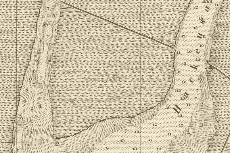
Figure 6: 1845 U.S. Coast Survey Map Depicting Depth Readings of Passaic and Hackensack Rivers
Photo Credit: David Rumsey Map Collection
Extensive dredging of the Passaic and Hackensack rivers from the late 1800s onward further altered the waters of the Hackensack Meadowlands. Initially both rivers had shallow beds: In 1845 the U.S. Coast Survey measured depths of 5 to 7 feet inside the mouth of the Passaic River and depths of 10 to 18 feet at the mouth of the Hackensack River (U.S. Coast Survey, 1845) (Figure 6). The dredging allowed larger amounts of seawater to flow north from Newark Bay into the rivers' deepened channels.
During the late 1800s the U.S. Army Corps of Engineers began dredging Newark Bay, and then the Passaic and Hackensack rivers (Klawonn, 1997; Iannuzzi et al., 2002; Livermore, 1905). During the 1880s, the corps dredged a 200-foot-wide channel 10 feet deep along the lower Passaic River bordering Newark. Later dredging deepened and extended the Passaic River channel, which is now 30 feet deep for the first 2 ½ miles and 20 feet deep for the next 4 ½ miles (U.S. Army Corps of Engineers, 2004).
Dredging of the Hackensack River began in the 1900s, when the corps dug a 12-foot-deep channel. The current Hackensack River channel is 32 feet deep for the first 3 miles, 25 feet deep for the next ¼ mile, and 15 feet deep for an additional ½ mile. The channel varies between 800 and 200 feet in width.
The decrease in the volume of freshwater flowing in the Passaic and Hackensack rivers and the dredging of the riverbeds to three to four times their original depths allowed the saltwater in Newark Bay to flow farther and farther north into the Hackensack Meadows. The freshwater wetlands at the northern part of the Hackensack Meadows began turning brackish, and the brackish wetlands in the middle and southern part of the Hackensack Meadows were transformed into saltwater habitats. Phragmites and other plants associated with brackish and freshwater wetlands were displaced by Spartina and other species associated with saltwater wetlands (Ehrenfeld, 2000; Ravit, 2002).
Extensive forests of cedar trees covered parts of the Meadowlands as late as the early 1800s, but they can no longer grow there because of the salinity of the surface and ground water ("Meadows Were Once Newark Forests," 1936; Heusser, 1949; Sipple, 1971; Harshberger & Burns, 1919; Wright, 1988). The only forested area now located within the boundaries of the Meadowlands is a small grove of deciduous trees at Schmidt's Park in an upland section of Secaucus.
Reclamation, Land Making, and Development
The third type of human alteration of the Meadowlands was the structural transformation of portions of wetlands into dry upland. The initial efforts, during the 19th century, were land-reclamation projects involving dikes and drains that left the reclaimed acreage below the high-tide level. Later, in the 20th century, land-making projects resulted in new upland above the high-tide level. Both types of projects were aimed at "improving" wetlands by transforming them into dry upland suitable for agricultural, commercial, and industrial uses.
Distinctions between the different types of structural transformation (and the appropriate terminology) were commendably noted in a recent comprehensive study of Boston's former wetlands (Seasholes, 2003):
The Quincy Market area, the Bullfinch Triangle, and the airport...were also once under water. Like many areas of Boston, they are "made land," created by filling in the tidal flats and marshes that once surrounded the city—a process that can be termed land making. Many call this process land filling or land reclamation. But neither term is correct. Landfill not only evokes images of garbage dumps but can also mean fill added on top of existing land. And since in Boston it was water that was filled, not land, landfilling is actually an oxymoron. Land reclamation is not an accurate term either, for land in Boston was actually made by filling, not by diking, pumping, and draining to reclaim it from the sea. So land making, a term coined by archaeologists, has been chosen as the appropriate term for this study, because it describes what really occurred in Boston—making land by filing in areas of water.
The Newark and Hackensack meadows experienced a pattern of development different from that of the Boston wetlands because the initial wetlands development projects were land-reclamation efforts. The largest pre–Civil War projects were undertaken by the New York City–based Swartwout family, from the 1820s through the 1840s. Robert Swartwout and his brothers organized a variety of companies to construct a system of earthen dikes and tidal gates to reclaim several square miles of land located between the lower Hackensack and Passaic rivers and develop them as farmland. Their companies, however, were all economic failures (Sullivan, 1998; Brooks, 1957).
The next major reclamation project occurred after the end of the Civil War. An engineer, Spencer B. Driggs, teamed up with New York City real estate developer Samuel Pike to reclaim the same portion of the Meadowlands as the Swartwouts had. Driggs and Pike also used a system of dikes and tidal gates, supplemented by water pumps (Iron Dike and Land Reclamation Company, 1867; "The New System of Reclaiming Lands," 1867). They also introduced the practice of building the earthen dikes around large overlapping iron plates, designed to prevent muskrats and other animals from burrowing through and weakening the dikes. The death of Pike in 1872 and the onset of the financial depression of 1873 led to the abandonment of the project (Figures 7 and 8).

Figure 7: Reclamation of Lower Hackensack Meadows (1), 1867
Photo Credit: Frank Leslie's Illustrated Newspaper, November 16, 1867.
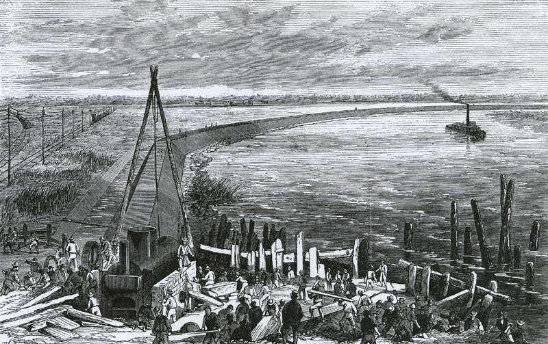
Figure 8: Reclamation of Lower Hackensack Meadows (2), 1867
Photo Credit: Frank Leslie's Illustrated Newspaper, November 16, 1867.
During the latter half of the 19th century, government officials joined private businessmen in advocating development of the Meadowlands. Several influential Newark businessmen (and two U.S. senators, John Kean of Elizabeth and James Smith Jr. of Newark) proposed various projects to reclaim all or part of the Newark Meadows. ("Draining the Meadows," 1884). The Geological Survey of New Jersey made several visits to inspect reclamation projects in Holland and in the Fens region of England. State geologists issued reports recommending the reclamation of the Meadowlands, which they characteristically described as "a blot upon an otherwise fair landscape," using a combination of dikes and dredged navigation channels (Vermeule, 1897, 1898). These state reports were supplemented by studies conducted by engineers retained by the city of Newark (Greene & Adams, 1909; Owen, Hand & Goodrich, 1909).
Until the early 1900s, all development proposals for the Meadowlands were based on reclamation technologies using dikes and drains similar to those used in the Netherlands (albeit without windmills). According to these plans, the reclaimed land would lie below the high-tide level and would be devoted to farming. Although cities and industries were located behind dikes in the Netherlands and behind Mississippi River levees in Louisiana, none of the 19th-century Meadowlands reclamation projects proposed using the reclaimed lands for any purpose except farming.
In the 20th century, however, the major Meadowlands reclamation proposals advocated the more expensive land-making technologies of dredging and filling in. Instead of creating reclaimed land lying below the level of high tide, the developers proposed using massive amounts of fill to permanently elevate the reclaimed land several feet above high tide. Some of the fill would be obtained by dredging navigation channels in nearby rivers and bays. Other sources of fill were municipal garbage and excavation debris from the construction of tunnels, skyscraper foundations, and subways.
This new reclamation method was much more expensive, but proponents argued that the resulting permanent upland could be used for a larger number of activities. The higher initial investment would be offset by higher rents and larger profits realized from developing the new upland, assured by the increasing demand for real estate arising from the growing metropolis.
The burgeoning urban population in the late 1800s created a growing demand for land in the vicinity of New York City. Between 1870 and 1900, the city's population increased from 1.5 million to 3.4 million. In New Jersey, Newark grew from 115,000 to 287,000 (Mitchell, 1993). In 1870, the combined population of Essex, Union, Hudson, and Bergen counties was only 345,000 persons; by 1900, the combined population of the four counties had nearly tripled, to 924,000 (N.J. Department of State, Census Bureau, 1906; New Jersey State Data Center, 1991).
Starting in the early 1900s, the New Jersey Terminal Dock and Land Improvement Company began attempting to transform five square miles of land between the Hackensack and Passaic rivers (the same site as the Swartwouts' and the Driggs-Pike projects). The company's organizers were associated with a firm engaged in dredging Ambrose Channel in New York Harbor and other dredging projects in Newark Bay and the Passaic River. In addition to the dredge spoils from its projects, the company also used excavation debris from the construction of the trans-Hudson tunnels and garbage transported in barges from New York City.
The expanding urban population, combined with increasing prosperity, resulted in a rapidly growing amount of garbage (Strasser, 1999). Garbage collected by private scavengers or municipal agencies was mixed with clean fill (chemically inert solid materials, such as rocks, gravel, cinders, bricks, and concrete) and used for the new land-making projects. In 1909 a Newark newspaper reported (admiringly) that "New York rubbish is being turned into Jersey soil by scow after scow from Manhattan." ("Sees Need of Rushing Canal," 1909).
The city of Newark started constructing Port Newark in 1914, dredging a ship channel one mile long from Newark Bay into the Meadowlands. The city mixed the dredged fill with garbage and ashes and dumped it on the wetlands on the north side of the channel. Eventually, the land was elevated several feet above sea level, and docks and warehouses were constructed on it (Hallock, 1914).
Additional portions of the Newark Meadows were similarly reclaimed during the 1920s for the expansion of Port Newark and the construction of the original Newark Airport. These land-making projects elevated the wetlands by using a combination of fill: dredge spoils from Newark Bay, Newark garbage, and excavated fill from the construction of Newark's skyscrapers and subway system. Between 1914 and 1974, the Newark Meadows portion of the Meadowlands was totally filled in and covered by the Port Newark/Elizabeth marine terminal, Newark Liberty International Airport, and the New Jersey Turnpike (Hallock, 1914; Folson, Fitzpatrick & Conklin, 1925; Cunningham, 2002).
The Hackensack Meadows were not developed until much later than the Newark Meadows. The Hackensack Meadows were divided among many more municipalities, and none of these local governments had the resources to finance a major land-making project. Although construction of Teterboro Airport started during World War I, most of the development of the Hackensack Meadows came several decades later, and in much smaller increments than the giant construction projects of Port Newark and Newark Airport. However, from the 1920s through the 1960s, more than half the acreage of the Meadowlands lying north of Newark Bay was filled in to make new upland (Meadows Reclamation Commission, 1930; Mattson, 1970; Baldi, 1981; Sellnow, 1930).
Large-scale proposals to develop the remaining Meadowlands arose in the 1950s, after the construction of the New Jersey Turnpike along its eastern edge. Placement of a turnpike interchange at Route 3 in Secaucus began the transformation of a small village known primarily for its pig farms into a substantial city known for shopping malls and factory outlets. The Meadowlands Regional Development Agency was created by the state legislature in the late 1950s to facilitate Meadowlands development, but it was mainly a fact-finding body and had little impact (Sullivan, 1998; Rockland & Gillespie, 1993; Meadowlands Regional Development Agency, 1960).
Further incentive for developing the remaining portions of the Meadowlands came during the late 1960s, when the New Jersey Turnpike Authority decided to widen the existing turnpike and construct a western spur through the very center of the wetlands to connect with Route 3 in East Rutherford, near the Hackensack River. The administration of Governor Richard Hughes predicted that this interchange would become the center of a major new city on the reclaimed wetlands, with housing, industry, commercial centers, and recreation facilities rivaling those of Manhattan. Governor Hughes persuaded the legislature to enact the Hackensack Meadowlands Development Act in 1968, to facilitate the development of the remaining Meadowlands. His successor, William Cahill, persuaded the legislature to enact the New Jersey Sports Authority Act in 1969, with the more focused mission of developing a major sports center at the intersection of the turnpike and Route 3 (Ginman, 1968; Goldman, 1975).
A dramatic change in public attitudes regarding the value of wetlands, along with new federal legislation in the early 1970s mandating stricter criteria for water pollution and wetlands reclamation, slowed efforts to develop wetlands. The 1972 election of Governor Brendan Byrne, who supported stricter state environmental laws and appointed more environmentally concerned commissioners to the HMDC, also slowed and then halted most efforts to develop the remaining Hackensack Meadowlands (Goldman, 1975; Goldshore, 1976).
Pollution
The fourth major type of human impact was pollution—the import and deposit of refuse, sewage, and hazardous wastes in the Meadowlands. This activity often involved making extensive structural changes to certain portions of the meadows, such as enlarging the old boundary ditches and digging wider and deeper sewage channels (Whigham, Simpson & Lee, 1980). The structure of the Meadowlands was also altered by the creation of large open dumps and sanitary landfills, although even the largest landfill in the Meadowlands is still only a fraction of the size of New York City's Fresh Kills Landfill on Staten Island (Rathje & Murphy, 1992).
In the 19th century, the southern portion of the Meadowlands began experiencing substantial pollution from the sewage and industrial wastes poured into the Passaic River. The effect of wastes from the growing cities and industries was aggravated by the fact that water-supply pumping stations, and later dams and reservoirs, were steadily decreasing the amount of freshwater flowing through the river (Iannuzzi & Ludwig, 2004; Iannuzzi et al., 2002; Galishoff, 1988; Brydon, 1974).
In the early 1900s, Newark, Paterson, and other cities along the Passaic River collaborated to construct a major trunk sewer line to pump sewage into Newark Bay, and later New York Harbor. This decreased pollution of the river to some extent, but Newark Bay remained extremely contaminated (Feng, Jaslanek, Stern, Jones & Onwueme, 2003; Modica, 2001; Crawford et al., 1994; Suszkowski, 1978; Gallishoff, 1970; Potts, Vermeule & Sherrerd, 1920).
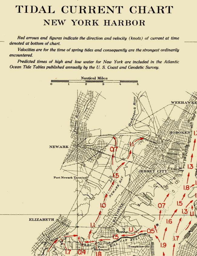
Figure 9: Tidal Current Chart, New York Harbor, 1946
Photo Credit: U.S. Department of Commerce, Coast and Geodetic Survey
The portion of the Meadowlands surrounding the Hackensack River initially experienced less pollution than the Passaic River section, largely because no large cities bordered that river. But the mean range of tides in Newark Bay was 5.1 feet, and tides entering the Hackensack extended as far north as New Milford, a distance of more than 21 miles (Figure 9). Twice each day, the waters (and waterborne pollutants) of Newark Bay would flow north into the Hackensack with a tidal current reaching 1.1 knots (Suszkowski, 1978; U.S. Department of Commerce, Coast and Geodetic Survey, 1946.)
Dredging of the Hackensack, which began in the early 1900s, facilitated the entry of larger volumes of these increasingly polluted tidal waters. At the same time, however, land making and construction of infrastructure upon the mud flats bordering both banks of the lower Hackensack in Kearny and Jersey City narrowed the river and acted to restrict the flow of fresh and tidal waters (Artigas & Yang, 2004).
In much the same way that garbage from Newark had been used in the land-making projects that destroyed the Newark Meadows, starting in 1906, New York City garbage was used to build up the five-square-mile portion of the Meadowlands between the mouths of the Passaic and Hackensack rivers.
Before then, New York City's garbage had either been dumped at sea or mixed with clean fill and used for land making at the tidal wetlands bordering lower Manhattan and the eastern shore of Brooklyn. During the mid-1800s, city garbage was also used for land making in the extensive tidal flats along the edge of Hudson County lying east of Bergen Hill (Miller, 2000; Walsh & LaFleur, 1995; Walsh, 1989; "Where Street Refuse Goes," 1869). Indeed, the precedent for using rubbish to create upland was such that "the present contours of virtually every portion of New York City and the neighboring parts of New Jersey and Long Island have all been shaped by fill, much of it garbage." (Rathje & Murphy, 1992.)
By the mid-20th century, even garbage not being used for land-making projects was brought to the Meadowlands. It was simply deposited in open dumps, and later, in sanitary landfills. The disposal of garbage in a manner that simply polluted and did nothing to make new land resulted from several factors. The most important factor was the growing population of New York City and adjacent municipalities, which generated ever-increasing amounts of garbage. In addition, the automobile revolution of the 1920s also provided relatively inexpensive trucks to transport garbage out of the city to the Meadowlands on the growing network of paved streets and highways (Miller, 2000; Melosi, 2000, 1981; Strasser, 1999; Colten & Skinner, 1995; Tarr, 1996; Hird, 1994; Goddard, 1975; Bower, 1968; Fee & Corey, 1994).
In 1957, New York City stopped providing municipal garbage removal for commercial firms, which required companies to hire private garbage collectors. Some of these private haulers were associated with organized crime and chose to eliminate the expense of garbage dump "tipping fees" by simply depositing refuse at any available unwatched location. Its highway access to the city, as well as its low population density and corresponding difficulty of identifying illegal dumpers, made the northern portion of the Meadowlands attractive for unregulated garbage dumps.
The explosive growth of the local garbage-collection industry after 1957—and corresponding increase in the frequency and quantity of illegal dumping in the Meadowlands—created a situation that might be called the Tony Soprano version of "the tragedy of the commons." When there are only two or three "midnight dumpers" operating intermittently on a small scale, their illegal operations might go unnoticed and undisturbed for a long time. But when dozens of dumpers begin making a continuous round of trips to an ever-increasing number of illegal sites, they arouse the attention of local residents, newspaper reporters, law-enforcement officials, and eventually the local and state governments.
As a consequence, when the New Jersey Legislature enacted the Hackensack Meadowlands Development Act in 1968, one of the resulting commission's primary goals was the elimination of illegal dumping and the enforcement of regulations concerning legal dumping at the Meadowlands. Changes in public attitudes regarding wetlands eventually led the commission to abandon its other original goal of actively promoting development and to strengthen its efforts to regulate garbage disposal (New Jersey Meadowlands Commission, 2002, 2003).
Over the past several decades, shifts in people's attitudes about wetlands and the recognition that much of the remaining portions of the Newark and Hackensack meadows have suffered extensive environmental damage have led to studies regarding the extent of the damage and possible means to remediate it. As a result, the commission (and the affiliated Meadowlands Environmental Research Institute) has become a major sponsor of wetlands environmental research (Meadowlands Environmental Research Institute, 2004).
Conclusion
During the 300 years before the creation of the Hackensack Meadowlands Development Commission, the Newark and Hackensack meadows experienced several important changes as the result of human use and alteration. The first 150 years of relatively benign extraction of natural resources was superseded by more drastic changes starting in the early 1800s. The steady decrease of fresh river water flowing into the Meadowlands and the later dredging of the river bottoms combined with a rising sea level to increase the salinity of the Meadowlands' waters. Initial land-reclamation efforts with dikes and drains, and later land-making efforts using dredging and filling, transformed more than two-thirds of the Meadowlands' 42-square miles into elevated upland.
In their seminal book Life and Death of the Salt Marsh, John and Mildred Teal noted, "The closer the marsh lay to New York City, the more likely it was that it was destroyed by the spreading urban complex." (Teal & Teal, 1969). The development of the Newark and Hackensack meadows was a minor variation on this theme: They were close to New York City, but even closer to Newark. The southern portion of the Meadowlands, comprising the former Newark Meadows and the five-square-mile portion of the Hackensack Meadows lying between Newark Bay and the PATH rapid-transit train lines, was completely developed and excluded from the jurisdiction of the Hackensack Meadowlands Development Act. The pattern of extraction, alteration, development, and pollution of the Newark and Hackensack meadows might also be useful for understanding the history of other degraded wetlands in the New York City area, as well as ones near Boston, San Francisco, and other urban centers.
Acknowledgments
This project was assisted by a grant from the New Jersey Historical Commission, a division of Cultural Affairs in the Department of State. Earlier versions of this paper benefited from criticism by Brett Bragin, Tom Maturano, and Tammy Marshall of the New Jersey Meadowlands Commission, Dr. Stan Hales of the U.S. Fish and Wildlife Service, Robin Grossinger of the San Francisco Estuary Institute, and, especially, an anonymous Urban Habitats reviewer. Brett Bragin provided a copy of the 1826 New-York Spectator; Clifford G. Day and Gene Nieminen of the U.S. Fish and Wildlife Service provided a digital copy of the 1896 map; and the New Jersey Meadowlands Commission and the Regional Plan Association granted permission to display maps prepared by their staff.