Using Citizen Science in Urban Bird Studies
by Rachel E. McCaffrey
School of Natural Resources, University of Arizona, Tucson, AZ 85721
Abstract
Long-term monitoring projects and studies designed to survey large, variable areas often face a similar challenge: data collection. Researchers can sometimes overcome this obstacle by designing studies that utilize the skills of volunteers, or citizen scientists. Citizen scientists currently play active roles in a wide range of ecological projects, and their contributions have enabled scientists to collect large amounts of data at minimal cost. Because bird-watching is popular among members of the general public, bird-monitoring projects have been among the most successful at integrating citizen scientists. Several large-scale studies, such as the Christmas Bird Count and Breeding Bird Survey, have successfully relied on citizen scientists to collect data. As urban areas expand and scientists work to find ways to manage wildlife in cities, information about the associations among animals and urban environments is needed. By utilizing the large pool of potential participants in urban areas, citizen science–based studies can play an important role in collecting this information. One such study, the Tucson Bird Count (TBC), has successfully utilized citizen scientists to collect information on the distribution and abundance of birds across an urban area. The results from the TBC have been used in numerous scientific studies, and they are helping wildlife managers identify important sites for birds within the city, as well as land-use practices that sustain native birds.
Key words: birds, bird survey, citizen science, monitoring, Tucson Bird Count
Introduction
The value of employing volunteers from the general public (i.e., citizen scientists) to collect data has been recognized for a long time, but there has been a recent surge in studies based on citizen science. Although many early citizen science programs were primarily conceived as educational tools—as a way to increase participants' knowledge about science (Brossard, Lewenstein & Bonney, 2005)—there has been a growing focus on the use of citizen scientists to collect long-term data (Brewer, 2002; Evans et al., 2005). For research projects that require many observers, such as studies designed to assess the status of local resources, establish baseline ecological measures, or identify the impacts of various activities on environmental quality, citizen scientists can be a remarkable resource (Ely, 2000; Altizer, Hochachka & Dhondt, 2004). In many cases, lone professional scientists, lacking the necessary funding and manpower, are unable to gather the broad-scaled yet detailed information that a cadre of citizen scientists can. As a result, citizen scientists are currently active participants in a wide range of ecological projects, including studies of macroinvertebrates and stream health (Fore, Paulsen & O'Laughlin, 2001), the status of reef fish and amphibian populations (Pattengill-Semmens & Semmens, 2003; Ebersole, 2003), and the distribution and abundance of monarch butterflies in North America (Monarch Larva Monitoring Project, 2001).
One area in which citizen scientists are widely utilized is in surveying and monitoring bird populations (Lepczyk, 2005). Several large-scale bird-monitoring projects, such as the Breeding Bird Survey (BBS), Christmas Bird Count (CBC), and Project FeederWatch (PFW) rely on volunteers to collect data. The involvement of citizen scientists in these projects provides the sponsoring agencies (BBS = the United States Geologic Survey and the Canadian Wildlife Service, CBC = the National Audubon Society, PFW = the Cornell Lab of Ornithology and Bird Studies Canada) with data that allow them to generate detailed distribution maps for species throughout the United States and monitor changes in bird populations over time (Root, 1988; Sauer, 2003). Additionally, data collected through these programs have been utilized in numerous scientific studies (see LePage & Francis, 2002; Sauer, Hines & Fallon, 2003; Dunn et al., 2005).
The benefits of incorporating citizen science into ecological research are not limited to the quantity of data that can be collected. Citizen science projects can also benefit the volunteers and the broader community. Volunteers not only gain experience in making observations and participating in a scientific study, they may also develop a greater sense of stewardship over the populations or sites they are responsible for surveying or monitoring (Carr, 2004). The broader community benefits from an increased sense of stewardship among the citizen scientists and from the fact that the data collected can serve to inform local planning and land-use decisions (Nerbonne & Nelson, 2004). In addition, when the results of citizen science projects are made accessible to the public, they can help to increase residents' knowledge and appreciation of both their local ecological resources and the scientific process (Brewer, 2002).
Despite the value of volunteers to research programs and the potential benefits to both participants and the broader community, citizen science–based projects have been criticized for lacking scientific rigor (Irwin, 1995). In order to encourage the participation of volunteers, scientists design programs that attempt to both minimize the time and effort required of participants and maximize the output of usable data. As a result, the design of such programs is often a compromise. The CBC, for example, has been criticized because there is variability in volunteer effort among and within count circles, and because the count circles are not randomly located (Dunn et al., 2005). Lack of randomly located survey sites is an issue with many citizen science projects because sites tend to be clustered near population centers (where the majority of participants live) or in ecologically rich areas (which participants are more interested in surveying). Additional concerns about the quality of data collected by citizen scientists include variability in skill levels among volunteers, underreporting of negative results, and the impact of participants' biases on data quality (Irwin). In response to these concerns, many existing projects have developed innovative ways to standardize data collection (Dunn et al.) to make analysis and interpretation of results more reliable.
Given the increased interest in citizen science and the development of improved methods of data collection, researchers have begun to explore new opportunities for involving citizen scientists. One area in which there is significant potential for developing citizen science–based projects is in urban centers. While underrepresented in many traditional ecological surveys, studies based in urban areas have increased as more and more scientists are investigating the relationships between people and their environments (Marzluff, Bowman & Donnelly, 2001). Conducting comprehensive studies in urban areas frequently poses challenges to scientists because cities generally are large and consist of variable environments. Collecting representative information from such large, diverse areas requires considerable manpower, and in urban areas citizen scientists can help meet this need.
Among the more common types of ecological projects utilizing citizen scientists in urban areas are studies examining urban bird populations. Using information collected by residents, researchers in England have been able to investigate the distribution and geographical abundance of house sparrows (Passer domesticus) throughout London (Royal Society for the Protection of Birds, 2004). At urban and suburban sites throughout the Washington, D.C., area, citizen scientists are gathering data about the nesting success and survival rates of their backyard birds through the Smithsonian Institute's Neighborhood Nestwatch Program (Smithsonian Institute, n.d.). The Cornell Lab of Ornithology currently has five ongoing citizen science–based studies targeting urban birds (Cornell Lab of Ornithology, 2004). Another project that has utilized citizen scientists to collect data on bird abundances and distributions in an urban area is the Tucson Bird Count (Tucson Bird Count, n.d.).
Methods
Case Study: The Tucson Bird Count
The Tucson Bird Count (TBC) is a volunteer-based bird-monitoring project in Tucson, Arizona (Turner, 2003). The TBC was established in 2001 to acquire information about the distribution and abundances of birds throughout the Tucson area. Tucson has been the setting for many studies investigating the relationships among birds and urban environments (see Emlen, 1974; Tweit & Tweit, 1986; Mills, Dunning Jr. & Bates, 1989; Germaine, Rosenstock, Schweinsburg & Richardson, 1998), but each of these studies was restricted in coverage, in space, or in time. Furthermore, nationwide bird-monitoring programs, like the CBC and the BBS, do not provide detailed information on birds in Tucson. The CBC includes a count circle in Tucson, but due to the nature of this project, surveys occur in the winter, when many species that breed in or migrate through Tucson are not present (National Audubon Society, 2005). And though the BBS surveys birds during the spring breeding season, urban areas are generally avoided in count circle placement (O'Connor et al., 2000), and there are no BBS survey sites in Tucson (Sauer et al., 2005).
The long-term goal of the TBC is to help identify ways to restore and sustain native bird species (Turner, 2003). The initial design of the TBC focused on counting birds at random sites covering a wide range of environments throughout Tucson during the breeding season (the Route Program). The original sampling scheme allowed for inferences about bird/habitat associations to be drawn from the TBC data (Ramsey & Schafer, 2002), but several of the most bird-rich sites in Tucson were not included. As a result, the Park Monitoring Program was established as an additional component of the TBC. In the Park Monitoring Program, volunteers survey birds in their local parks, washes, or other areas of interest on a quarterly basis. Experience gained from designing the TBC program, recruiting volunteers, making the data available to the public and researchers, and confronting the challenges associated with such a study, can serve as an example for other researchers interested in establishing citizen science–based projects in urban areas.
Study Design: The Route Program
The design of the TBC Route Program is modeled after that of the BBS: One survey site is randomly located within each one-square-kilometer (1 km²) cell of a grid covering the Tucson area, following a stratified random sampling design (for a detailed description, see Turner, 2003). Adjacent sites are grouped into routes, with an average of ten sites per route. Using maps and information available at the TBC website, volunteers select a route (or routes) to survey. (Once a route is adopted, it is unavailable to other volunteers.) Each year between April 15 and May 15 (the peak breeding season in Tucson), volunteers survey the sites along their route on a morning of their choice, conducting a five-minute unlimited-radius point count (per Blondel, Ferry & Frochet, 1981) at each site.
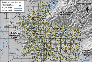
In 2001, 661 randomly located sites on 63 routes in the Tucson area were surveyed (Tucson Bird Count, n.d.). With the exception of sites that have been relocated due to changes in accessibility or other disruptive factors, site locations are permanent, allowing for the same sites to be surveyed each year. Tucson has grown by more than 30 square miles since 2000 (City of Tucson, 2005), and additional sites have been added to the Route Program in newly developing areas around the edges of the city. In 2005, 772 sites on 72 routes were surveyed (Tucson Bird Count, n.d.; yellow dots in Figure 1). Due to the volunteer-based nature of the TBC and the fact that participants select the routes they want to survey, there is no guarantee that all routes will be adopted every year. As a result, each year a few routes are not surveyed. To avoid gaps in coverage, routes that were not surveyed one year are given priority the following year, or are surveyed by TBC staff.
Study Design: The Park Monitoring Program
Locations monitored in the Park Monitoring Program (red stars in Figure 1) were selected by TBC personnel and volunteers and include neighborhood, city, and regional parks, washes, a national park, and other key birding spots (referred to as parks here). The number of survey sites per park varies from 3 to 14, depending on the size of the site and the variability of environments contained within the park. To gain a better understanding of how Tucson's bird populations change throughout the year and to detect species that may not be present during the Route Program survey period, parks are monitored four times a year: winter (January 15–February 15); spring (April 15–May 15), covering spring migration/breeding; summer (July 1–31); and fall (September 1–30), covering fall migration.
Volunteers use a combination of point counts and transects to survey birds at park sites (Tucson Bird Count, 2005). To make sites monitored in the park and Route Program comparable, five-minute unlimited-radius point counts are conducted at most sites. However, at sites with relatively open and uniform environments (Sutherland, Newton & Green, 2004), or at sites where the structure of the vegetation is more conducive to the use of line transects (e.g., a wash bordered by riparian vegetation), participants survey 200-meter transects for ten minutes (Bibby, Burgess & Hill, 1992). To reduce the chances of double-counting birds, point-count locations are separated by at least 250 meters, and transects do not cross each other (Sutherland et al.). Currently, the TBC surveys 178 sites in 21 parks in the Tucson area through its Park Monitoring Program.
TBC Participants
The TBC is performed primarily by volunteer birders from the Tucson community. In order to ensure that data collected in the TBC is of high quality, participants must be knowledgeable birders. To participate in the TBC, volunteers must meet the project's definition of a skilled observer, defined as "one who can identify the 25 most common Tucson-area species quickly by sight or sound, is familiar with most other birds of the Tucson area, and may need quick reference to a field guide for certain less-common or difficult-to-separate species" (Turner, 2003). To determine if participants meet this criteria, volunteers are required to take a self-test at the TBC website prior to adopting a route.
The presence of a large group of active and experienced birders in the Tucson area has been key to both the establishment and continuation of the TBC. At the initiation of the count, in 2001, volunteers were recruited through the Tucson Audubon Society newsletter, the Arizona/New Mexico birding e-mail listserv, and personal communications between TBC staff and local birders (Turner, 2003). Since 2001, new volunteers have been recruited through presentations about the TBC by project personnel, articles in the local media, and referrals from existing volunteers. In 2001, 51 primary observers and 30 additional observers participated in the Route Program, and 7 primary observers and 6 additional observers participated in the Park Monitoring Program. In 2005, 58 primary observers and 29 additional observers participated in the Route Program, and 21 primary observers and 18 additional observers participated in the Park Monitoring Program.
To decrease the time and effort required of TBC personnel in recruiting new volunteers, an emphasis is placed on retaining skilled volunteers. Since 2001, an average of 79% of volunteers have returned from year to year. This relatively high rate (Bradford & Israel, 2004) is achieved by following several known principles of volunteer retention: creating motivation, providing options, and maintaining connectedness (McCurley & Lynch, 1997). The motivation for volunteers to initially and persistently participate in the TBC is in many cases related to the goal of collecting data that will be used to help sustain native birds in Tucson. All TBC participants are skilled birders, thus a project designed to aid in bird conservation and identify the distribution and abundances of birds throughout Tucson is closely aligned with the interests of the participants.
Providing people with options that meet their level of interest in the program also aids in volunteer retention. For example, TBC participants can choose to take part in either (or both) the Route Program or the Park Monitoring Program, depending on their interests. Additional options are offered to participants as they select their route or park to survey, and they can change their selections from year to year. Participants changing the areas they survey could potentially reduce the consistency of results, but excessive changes have not happened. Rather, allowing participants this freedom and flexibility of selection has helped them find areas they are interested in monitoring long-term.
Finally, connectedness is maintained between TBC personnel and project participants in several ways. First, the results submitted by each TBC participant are available immediately and publicly on the TBC website, so volunteers are able to see how their results fit into the overall project. Second, via e-mail, articles in the Tucson Audubon Society newsletter, and a recently established annual newsletter, participants are regularly updated about the TBC's results and how they are being used.
TBC Website
The TBC website was designed to facilitate participants' involvement in the project, make the data collected through the project easily accessible to the public, and provide information about the project to interested parties. At the website, participants can register for the TBC, take the required self-test, view a map of available routes, select a route or park to survey, enter their data, and view results. Enabling participants to carry out these administrative tasks themselves reduces the burden on TBC personnel and speeds up the process. An additional benefit of participants entering their data via the website is a decreased risk of transcription mistakes, as participants themselves (as opposed to TBC personnel) are entering data that they recorded. The data is automatically recorded in the TBC's digital database, allowing participants to immediately review their results (and make corrections, if necessary). To further ensure the validity of the data, TBC staff review all count results submitted, correct obvious errors, and contact participants to verify any unusual or unexpected observations.
Results entered by participants are publicly available in real time on the TBC website in tabular format and as distribution maps. As a result, during each survey period, the tables and maps are constantly updated as participants enter new data. By clicking on any of the survey sites on a distribution map, users can view which other species were observed at the site. The results and distribution maps from previous Route and Park Monitoring Program surveys can also be viewed at the website, allowing users to see how the distributions or abundances of various species have changed over time. An additional tool available on the TBC website is the Bird ID Center. At this page, users can view photos, hear the calls, and read an identification description from the USGS Patuxent Bird Identification Center (Gough, Sauer & Iliff, 1998) for more than 150 species found in the Tucson area.
The results and information available at the TBC website are also intended to inform researchers and local decision makers about the TBC and the data available from it. One of the advantages of having the TBC data in a digital database is that this data can be easily accessed by other users (Dunn et al., 2005). The TBC website contains a listing of projects, presentations, and publications that have made use of the TBC data so far.
Results
General Species Distribution Patterns
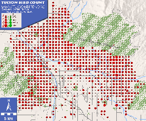
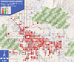
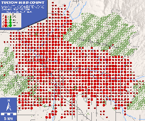
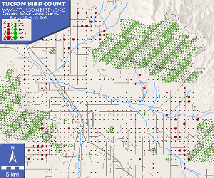
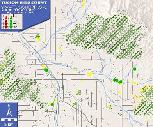
Data collected by citizen scientists through the TBC has enabled the generation of detailed Tucson-area distribution maps for more than 200 bird species. These maps indicate that many species follow distinct distribution patterns in Tucson. A group of native desert birds, exemplified by Gambel's quail (Callipepla gambelii), have similar distributions, with relatively high numbers of individuals on the less developed edges of Tucson, but few individuals occupying the city's more urbanized center (Turner, 2003; Figure 2). Rock pigeons (Columba livia), on the other hand, are among a group of species that exhibit the inverse pattern, reaching their highest abundances toward Tucson's urban core (Figure 3). Other distribution patterns are apparent in the data, including the restriction of some species to riparian areas and the concentration of others in areas of relatively dense native woodlands (Turner, 2003). Some bird species, such as mourning doves (Zenaida macroura), Gila woodpeckers (Melanerpes uropygialis), and house finches (Carpodacus mexicanus) have been counted in relatively high numbers at almost every survey point (Figure 4). Yet species more sensitive to development, such as the rufous-winged sparrow (Aimophila carpalis), are found in relatively small numbers and only at the very edges of the city (Figure 5).
Differences Between the Route and Park Monitoring Programs
Since the initiation of the TBC in 2001, participants have recorded more than 164,000 birds representing 212 species. A total of 158 species have been recorded through the Route Program, and a total of 202 species have been recorded through the Park Monitoring Program. Fifty-four species observed through the Park Monitoring Program have not been counted through the Route Program. This difference is largely attributable to two factors. First, Tucson has a semiarid climate, and wetlands are relatively rare among the randomly located sites in the Route Program; however, several of the locations monitored in the Park Monitoring Program contain ponds, lakes, or rivers. As a result, many water-associated species, such as the American wigeon (Anas americana), have only been observed at park locations (Figure 6). Second, the more intensive nature of the Park Monitoring Program, with its quarterly monitoring and multiple sites per bird-rich location, has resulted in sightings of several less common species, such as the golden eagle (Aquila chrysaetos), Lewis's woodpecker (Melanerpes lewis), and Hammond's flycatcher (Empidonax hammondii), not found in the Route Program.
Despite these differences, both programs are complimentary projects designed to provide us with a better understanding of the distribution and abundance of birds in Tucson, as well as which sites are particularly important for birds. Through the Route Program we collect data annually from hundreds of sites across the Tucson area, and this allows us to understand better the distribution of birds citywide and monitor year-to-year changes in Tucson's bird population. Through the Park Monitoring Program, we collect year-round data at several bird-rich sites, and this helps us develop a more complete picture of all the bird species that occur in Tucson and evaluate the importance of these park locations to birds.
How the TBC Results Have Been Used
Scientists have used TBC results to assess how species respond to different types of land use (Turner, 2003), investigate the relationship between the distribution of birds and people in Tucson (Turner, Nakamura & Dinetti, 2004), and examine the effects of nonnative cavity-nesting birds on the health of saguaro cacti (Carnegiea gigantea; Hutton, 2005). In addition, data from the TBC have served as baseline information for a number of scientific studies, ranging from an investigation of the impact of West Nile virus on Tucson's birds to a comparison of riparian birds in Tucson and Phoenix riparian areas. The TBC data has also been used in local land-use planning (Pima County, 2004), and to evaluate potential sites for natural resource parks (Rosen & Mauz, 2001).
Challenges and Lessons Learned
While the TBC is an example of how citizen science and urban ecological monitoring can be integrated, executing such a program poses challenges. Both components of the TBC—the citizen scientists and the urban setting—have presented obstacles over the program's five-year history. All TBC volunteers are required to take a self-test prior to registration to ensure that they meet minimum requirements, but variation remains among participants' abilities to detect birds by sound and sight. With the TBC, this hurdle is overcome in survey design (routes are arranged so that multiple observers cover any one part of Tucson) and during data analysis (patterns of distribution and abundance are analyzed at broad scales, rather than at specific points, reducing potential observer biases). The volunteer nature of a citizen science–based project also poses challenges. With the TBC, this has manifested itself in the difficulty in getting certain routes monitored—those that are deemed less "birdy" or are otherwise unattractive to participants. In Tucson, many of these routes are clustered in one region of the city, and the less frequent monitoring of these routes has led to gaps in the TBC's citywide coverage. Initial attempts to combat this problem by encouraging existing participants to adopt these routes were relatively unsuccessful. To solve the problem, future efforts to increase monitoring in gap areas will center on 1) working more directly with local residents, many of whom are minorities, to involve them in the TBC; and 2) establishing a core set of participants willing to cover the highest-priority unadopted routes each year.
All long-term monitoring projects encounter changes in the environment surrounding their monitoring sites, but projects conducted in urban settings may encounter such changes at a more rapid rate. For the TBC, such changes have often resulted in difficulty accessing established sites due to land-use changes. The conversion of public land to private land, the gating of large, residential neighborhoods, expansion of roads, and new construction have all impacted TBC sites, requiring some to be relocated. To keep site relocations to a minimum and to provide stable monitoring sites for the future, all TBC sites were recently evaluated, and sites in danger of future relocation were moved to nearby positions expected to be more permanent. Key to the changing nature of the TBC's urban setting is Tucson's ongoing expansion. In order to continue to provide citywide information on Tucson's birds, the TBC has had to expand as well, adding new routes as needed. While such expansion ensures that the TBC keeps pace with Tucson's boundaries, it also requires additional volunteers and TBC personnel time to establish the routes.
Conclusions
The TBC demonstrates the value of utilizing citizen scientists to collect citywide data for monitoring urban birds. Currently, the TBC is the only recurring volunteer-based, citywide urban bird-monitoring project in the world (Turner, 2003). Lessons learned through the TBC about study design, volunteer management, and the importance of making results available and useful may be helpful in the establishment of other urban bird-monitoring projects. Urban areas offer enormous potential for citizen science projects, not least because a large number of prospective volunteers are already in place. The ecology of urban areas is a growing field that requires further investigation; the type and scope of information citizen scientists can provide is invaluable. In the case of bird-related projects, there is the additional advantage that many experienced birders are interested in participating in projects designed to benefit birds, and they bring an established skill set to the project.
The breadth of data that can be collected by an organized group of citizen scientists allows researchers to conduct studies that might otherwise be impossible: Patterns of distribution and abundance can be mapped on a large scale and surveys can be regularly repeated, enabling researchers to monitor changes in populations over time. Results from these studies can be invaluable in identifying key areas of ecological importance within a city and tracking how changes in land use and other environmental factors influence bird communities. As urban areas expand, determining how populations of native wildlife can be sustained in cities is becoming more important. Data collected by citizen scientists can be a vital tool in helping meet this challenge.
Acknowledgments
The Tucson Bird Count is supported by the Arizona Game and Fish Department and the National Park Service. W. Turner, R.W. Mannan, E. Schlager, C. Remington, and an anonymous reviewer provided insightful comments on earlier drafts of the manuscript. I am particularly grateful to the dedicated participants of the Tucson Bird Count.

