
A Baseline Characterization Approach to Wetland Enhancement in an Urban Watershed
by Beth Ravit1, Christopher Obropta1,2, and Peter Kallin3
1Department of Environmental Sciences, Rutgers University, New Brunswick, New Jersey 08901
1,2Rutgers Cooperative Research and Extension, Rutgers University, New Brunswick, New Jersey 08901
3Belgrade Regional Conservation Alliance, P.O. Box 250, Belgrade Lake, Maine 04918
Abstract
During the 20th century, more acres of forested wetlands were lost than any other category of wetland, yet restoration or creation of this wetland type has been notably unsuccessful. Restoration of riparian forested wetlands that are located within highly urbanized landscapes is particularly problematic, due to the stresses placed on the wetland by historical alterations and disturbances and by current watershed land uses. The Teaneck Creek Conservancy has partnered with scientists and engineers at Rutgers University to provide a baseline characterization of the 46-acre Conservancy site located within Bergen County, New Jersey's Overpeck Park. The project goal is to rehabilitate 20 acres of forest and scrub/shrub wetland by establishing hydrologic conditions typically found in a temperate forested riparian corridor, on a site whose surrounding land use is categorized as 95 percent urban. To achieve the project goal, hydrologic connections must be reestablished between the creek and the interior surface and groundwater, and surface elevations must be lowered, historical debris removed, and native vegetation established to replace invasive species. This paper reviews briefly the current status of forested wetland restoration and the obstacles to achieving successful restoration of these ecosystems. We also describe the baseline characterization being conducted for the Teaneck Creek project to support efforts to establish a sustainable urban wetland system on the Conservancy site.
Keywords: Urban wetland, urbanization, riparian forest, restoration, hydrology, scrub/shrub wetland, restoration/creation
Introduction
Click image to enlarge
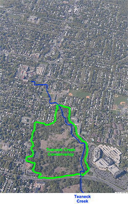
Figure 1: Arial photograph of Teaneck Creek Conservancy wetlands and surrounding urban land use. (Photo courtesy of Bergen County Parks Department.)
Wetlands provide numerous benefits to humans (Costanza et al. 1997). Wetlands' capacity to improve water quality, provide flood storage, retain and remove nitrogen, host wildlife habitat, and promote the general preservation of diminishing open space (Hammer 1996; Richardson and Vepraskas 2001) is of particular importance when a wetland is situated in a highly urbanized area, as is the Teaneck Creek watershed. The 46-acre Teaneck Creek Conservancy (TCC) restoration site is in Overpeck Park in Bergen County, New Jersey, which is located within the New York–New Jersey metropolitan area, one of the most densely populated urban regions in the world. Teaneck Creek and its wetland system are surrounded by land use that is categorized as 95% urban (Figure 1). Over the past two centuries, these wetlands have been influenced by a number of anthropogenic impacts and have served as a repository for multiple layers of various fill materials (Arnold this volume). The effects of this historic degradation are critical factors in determining whether and how the wetlands on this site can be restored/enhanced (Wolin and Mackeigan 2005), and they dictate to some degree the actions required to achieve an increase in sustainable wetland acreage (Zedler 1999).
Scientific research to characterize existing hydrology, vegetation, and soils on the Conservancy site has been ongoing since 2003, and the data collected will serve as the basis for developing a Conceptual Restoration Plan. While it is obviously not possible to fully restore the Teaneck Creek watershed to some previously pristine state (Zedler and Leach 1998), our overall goal is to establish hydrologic conditions typically found in a New Jersey temperate forested riparian corridor. For the purposes of this project, we are defining "restoration" as the establishment of 20 acres of forested and scrub/shrub wetlands within the 46-acre site. Although we acknowledge that this is not the usual definition of "restoration," for the sake of simplicity we will use this term to refer to the project's objective. Specific goals for the project include protecting existing high-quality native areas, creating new wetland acreage through the removal of fill materials and the lowering of surface elevations, and reestablishing a hydrological connection between Teaneck Creek and the interior wetlands and groundwater.
Click image to enlarge
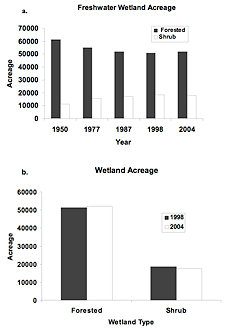
Figure 2: U.S. freshwater forested and scrub/shrub wetland acreage a) from 1950 through 2004; and b) in 1998 and 2004. Data reproduced from Dahl (2005).
Sustainable wetland ecosystems require specific combinations of water supply, topography, and soil characteristics (NRC 2001), and to determine the success of a wetland restoration or enhancement project, these interrelated attributes are typically compared to a specific wetland reference site. As we develop the restoration strategy for this site, our team is aware of the lack of success experienced by managers who have attempted to restore shrub swamp and forested wetland ecosystems both across the U.S. and in New Jersey. These two wetland types have been characterized as particularly difficult to restore (NRC 2001; Balzano et al. 2002; Minkin and Ladd 2003), in part because of the time and conditions needed to establish woody plants. The degree of difficulty encountered has been documented by the scientific community (NRC 2001), the U.S. Fish and Wildlife Service (Dahl 2000, 2005), the U.S. Army Corps of Engineers (Minkin and Ladd 2003), and the State of New Jersey (Balzano et al. 2002; ITRC 2005).
Although a gap exists in the peer-reviewed scientific literature describing successful restorations of forested riparian wetlands, reviews of regulatory permit information (Grayson et al. 1999; Dahl 2000; Sudol and Ambrose 2002; GAO 2005) and analysis of New Jersey wetland mitigation compliance (Balzano et al. 2002) verify that the success rate in restoring/creating freshwater riparian wetland systems is abysmally low. In the 2003 U.S. Army Corps of Engineers (USACE) study of overall wetland losses in New England (Minkin and Ladd 2003), forested wetlands accounted for 50% of all wetlands lost in this region (180 acres). However, the mitigation success to offset these losses totaled less than 20 acres. Field evaluation of 90 New Jersey freshwater wetland mitigation sites found only 1% of the proposed forested wetland acreage was achieved (Balzano et al. 2002).
In addition to the lack of reliable data for successful riparian wetland restoration, there is a similar lack of data for restoration of wetlands situated in highly urbanized areas. Despite some recent studies of urban wetlands (Ehrenfeld 2004, 2005; Burns et al. 2005; Wolin and Mackeigan 2005), the effects of surrounding urban land use on wetland hydrology, vegetation, and biogeochemical (Lamers et al. 2006) functions are not yet well understood. Urban wetlands differ from wetlands found in more natural settings in certain fundamental ways, including altered natural hydrology, high levels of anthropogenic site disturbance, and the frequent presence of invasive plant species (Guntenspergen and Dunn 1998; Ehrenfeld 2000). Urban wetlands may also experience continued anthropogenic disturbances after restoration work has been completed (Grayson et al. 1999; Magee and Kentula 2005).
Goals of the Teaneck Creek Wetland Restoration
Structural goals for this project include: 1) reestablishing a hydrologic connection between Teaneck Creek and the site's interior surface and ground waters; 2) the restoration of approximately 20 wetland acres to include riparian forest, scrub/shrub, and emergent water wetlands in locations where each type is sustainable under the given hydrologic regime and microtopography; and 3) within each wetland type, the establishment and survival of an appropriate native plant community. As a reference wetland to judge the project's success we will be using an on-site area where consistently saturated organic soils support diverse native vegetation. In addition to this on-site reference, we will identify a forested wetland site adjacent to the Tenakill Brook in Bergen County, New Jersey, as an off-site reference. We anticipate that achievement of the project goals will increase the residence time of Teaneck Creek water in the site's wetlands. Increased residence time will potentially increase the amount of nitrogen that these wetlands remove prior to water movement downstream into the lower estuary of the Hackensack River, where high porewater nitrogen levels have been observed in the salt marsh sediments (Ravit et al. in press).
Important factors to consider in meeting the project objectives are the current and historical alterations of the TCC wetlands and their surrounding urban hydrology, the large monospecific stands of Phragmites australis, the dominance of other aggressively invasive plants, and the large areas covered by the various historic fill materials. This paper will review issues related to freshwater wetland restoration, the conditions we encountered at Teaneck Creek, and the baseline characterization our team is using to develop a Conceptual Restoration Plan for the Conservancy site. Other papers in this volume discuss specific data related to the system's hydrology (Obropta et al. this volume) and vegetation (Ravit et al. this volume), and the effects of two disturbed upstream properties on the Conservancy restoration site (Bergstrom et al. this volume).
Issues in Forested Riparian Wetland Restoration/Creation
The TCC wetland degradation is historical, and so this project is not being undertaken as mitigation for wetland loss. However, today wetland fill permits allowing destruction of existing wetlands require compensatory mitigation. We use the term "restoration/creation" because much of the available data for management of forested riparian wetlands have been collected in conjunction with the U.S. Army Corps of Engineers (USACE) permitting process. Required mitigation may be achieved through restoration, creation, enhancement, and/or preservation of other wetlands, in order to compensate for the functions provided by the lost wetlands.
The greatest overall U.S. wetland losses have occurred in emergent and forested freshwater wetlands (Figure 2a), whose total acreage decreased by 6.9% in the decade prior to 1997 (Dahl 2000). Although forested wetlands accounted for up to 50% of wetland losses (Dahl 2000), the percentage of field-confirmed mitigation for these losses was only 5% (Minkin and Ladd 2003). More recent analyses (Robb 2002; GAO 2005) have found failure rates of over 70% for forested wetland restoration/creation. In a USACE study (Minkin and Ladd 2003), forested wetland impacts in New England totaled 178 acres, and the proposed "in-kind" mitigation was 25 acres. However, the actual successful forested wetland mitigation achieved was 0.5 acres. Analysis by the U.S. Department of the Interior (Dahl 2005) found increases of wetland acreage in the freshwater forested category (1998–2004) were due solely to natural succession that resulted in the movement of wetland acreage from the "shrub" to the "forested" category, with a corresponding decrease in shrub wetland acreage (Figure 2b).
Deciduous forested wetlands are the most abundant type of New Jersey wetland, equaling approximately 1/3 of the state's total wetland area (Ehrenfeld 2005). New Jersey's success rate in the mitigation of riparian and scrub/shrub wetland acreage has mirrored national trends. Field evaluation of 90 wetland mitigation sites concluded that although 41% of the mitigation projects proposed were forested freshwater, only 1% of the proposed acreage was achieved after an average of six years (Balzano et al. 2002). The reasons for the lack of success in restoring/creating shrub and riparian forested wetlands tend to fall into three broad categories: the topography, hydrology, and soils required to achieve targeted parameters.
In the Conservancy wetlands, these factors will be influenced to some degree by the stream channel itself, the adjacent upland land use (Zedler and Leach 1998), inputs from the overall catchment area (Mensing et al. 1998), and any surrounding anthropogenic disturbances, which may continue to occur post restoration (Burns et al. 2005; Wolin and Mackeigan 2005).
Hydrology
Hydrology is the dominant factor governing a wetland's type, development, maintenance, and functional attributes (Bedford 1996; NRC 2001). Hydrologic differences result from interactions between the wetland landscape and the hydrologic cycle, which in turn are driven by local climate conditions (Bedford 1996). Having a known and reliable water source is the most difficult factor to achieve when establishing wetlands (Minkin and Ladd 2003; Bedford 1996), and many wetland projects have been deemed unsuccessful because they lack suitable hydrology (Mitsch and Wilson 1996; NRC 2001; Balzano et al. 2002). As the degree of wetland degradation increases, the difficulties in restoring appropriate hydrology also increase (NRC 2001).
In New Jersey forested wetlands located in the Piedmont floodplain, a stable water table is primarily governed by the groundwater supply and source, which may be augmented by periodic over-bank flooding (Stolt et al. 2000). While the hydrology of undisturbed riparian wetlands is controlled by periodic river flooding, groundwater discharge and infiltrating, and precipitation (Wassen et al. 2003), urban wetlands typically have the additional factor of stormwater runoff inputs (Burns et al. 2005). Impervious surfaces and storm sewers accelerate the rate of stormwater movement into streams that drain into urban wetlands, where flow rates have been reported that are up to three times greater than the flows in undisturbed catchments (Burns et al. 2005). This is particularly true in densely populated locations such as Teaneck Creek, where the wetland is draining a highly developed regional catchment area of almost 300 acres (Bergstrom et al. this volume). In addition to determining flow rates, the water source will determine the nutrient and contaminant loadings entering an urban wetland.
Increases in surface water inputs can change the hydrology of an urban wetland, including the hydrograph, residence time, and temporal water variations (Bedford 1996; Zedler and Leach 1998), and urban hydrologic patterns are often quite different from the patterns found in natural wetland systems. An urban hydrologic pattern often seen is increased "flashiness": the rapid movement of water through urban storm systems into wetland stream(s), followed by a rapid elevation of stream water height, accelerated water flows through the stream, and then a rapid return to low flow water levels (Burns et al. 2005). Flashiness can also destabilize the stream channel (Sudduth and Meyer 2006), resulting in downcutting that can contribute to increased drainage of the wetland's subsurface water between storm events.
Restored/created freshwater wetlands have a tendency to exhibit greater "wetness," due to wetland engineers opting for a saturation period of 12.5% of the time. This is the upper limit of a transition zone described by Clark and Benforado (1981), whose range provided characterizations of upland versus wetland habitat; if a site is saturated less than 5% of the time it displays upland characteristics, and if saturated more than 12.5% of the time it will exhibit wetland characteristics. The USACE incorporated the 12.5% definition into their 1987 wetland delineation manual, and so wetland restorers use the conservative end of this scale, which results in wetter projects (Dahl 2005). This is especially problematic when attempting to restore forested riparian systems. If soils are too wet to support tree species, forested wetlands will not establish, and in fact wetlands that have been restored/created are often wetter than planned (NRC 2001).
Vegetation
Click image to enlarge
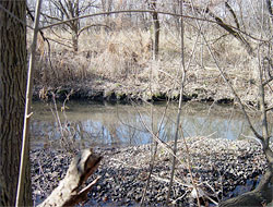
Figure 3: Phragmites australis monocultures in Teaneck Creek ponded depression areas.
Wetland plant communities are structured by fine-scale hydrologic conditions, and plant species cover is strongly correlated with mean water table depth, which may be altered or obscured by urban disturbances (Magee and Kentula 2005; Dwire et al. 2006). Predictors of wetland vegetation include water depth, inundation duration, and seasonal patterns of flooding, particularly with respect to woody plants, because reducing peak water flows enhances wetland succession from herbaceous to woody species (Toner and Keddy 1997). Differences of as little as 6 feet in the depth to the water table can shift inundated wet meadow plant communities to moist meadow communities, which are not inundated (Dwire et al. 2006).
While relatively little data have been collected on plant communities in forested urban wetland systems, diversity may be either quite high (Toner and Keddy 1997; Magee and Kentula 2005; Ehrenfeld 2005) or, conversely, species poor. In a set of 21 urban wetlands in northeastern New Jersey, species richness ranged from 29 to 119 species at a given site, and 15% of the species observed were exotic (Ehrenfeld 2005). Magee and Kentula (2005) observed high species richness (356 plant taxa) in urban wetlands, but more than 50% of these species were nonnative. Total vegetative cover is often lower in created versus natural wetlands, and the proportions of upland versus wetland species often differ. Structural and functional differences may result due to the wetland's age, species recruitment, and normal successional patterns (Grayson et al. 1999). Restoration success can be hampered by inappropriate actions of local property caretakers post-restoration, such as the practices of cutting wetland shrubs or regularly mowing newly created forested areas in an effort to give an advantage to woody seedlings (Minkin and Ladd 2003).
Deep flooding and long periods of ponding or standing water can decrease vegetation diversity and/or shrub densities, but conversely, these conditions may also decrease the number of invasive species able to establish (Ehrenfeld 2005; Dwire et al. 2006). In the few studies available, the majority of invasives observed were either upland or facultative upland species (Ehrenfeld 2005), suggesting that less saturated conditions may allow invasives to establish to the detriment of native wetland plant communities. Invasive species, particularly common reed (Phragmites australis), purple loosestrife (Lythrum salicaria), and multiflora rose (Rosa multiflora) were found to be common problems in eight restored New England wetlands (Minkin and Ladd 2003). Another problem is the introduction of cultivated varieties of native species, and the effect of these alien genotypes on wetland functions and/or other native species (Minkin and Ladd 2003). Heavy inputs of stormwater runoff can also potentially favor the dominance of invasive species (Joy Zedler personal communication). Wetland plants are affected by the amount of sedimentation and by nutrient inputs, both of which can enhance the growth of invasive species (Woo and Zedler 2002; Mahaney et al. 2004).
Soils
Undisturbed riparian wetland soils in the northeastern U.S. are often wet, acidic, and highly organic. However, soil characteristics that are important to nutrient cycling processes have been shown to be quite different in restored/created forested wetlands. In undisturbed riparian wetlands, the amount of soil organic matter is often two times higher than in constructed wetlands, and while sand may account for two thirds or more of the surface soil in restored/created systems, it is typically a negligible component of natural wetland soils (Campbell et al. 2002; Bruland and Richardson 2005). The proportion of silt and clay—often higher in natural wetlands—determines the soil particle size, which in turn determines permeability and porosity, and is inversely proportional to water holding capacity (Stolt et al. 2000). The cation exchange capacity (CEC), and levels of organic C and N have been found to be five to ten times higher in natural wetlands, and constructed wetlands typically exhibit a higher proportion of basic cations (Ca, Mg), and a higher pH than natural wetlands (Stolt et al. 2000).
Soil compaction appears to be common in wetland restoration projects, and created wetlands often exhibit a reduction of both large scale and microtopography, as well as an increase in the amount of low relief (Stolt et al. 2000). When an activity destroys fine-scale features such as microtopography (Stolt et al. 2000; Bruland and Richardson 2005), this reduction will result in a concomitant reduction of the "wetness" gradient that supports diverse plant species. The bulk density of soils in natural wetlands can range from 2-fold to an order of magnitude lower than the bulk density found in the restored/created wetlands soils, although the number of studies looking at this factor is small (Campbell et al. 2002; Bruland and Richardson 2005).
Location and Surrounding Land Use
Landscape position dictates the site hydrology and type of wetland that can be successfully restored and sustained (NRC 2001). However, degradation of the surrounding land can compromise wetland establishment and functionality, and so expectations and goals for urban freshwater wetland restorations need to be scaled to the surrounding landscape (Wolin and Mackeigan 2005). Parkyn et al. (2003) found isolated stretches of riparian buffer restoration produced few consistent improvements in water quality, habitat, or stream invertebrate communities. They suggest that "patches" of restoration may not be large enough to improve overall function of a given ecosystem, and so if upstream areas and/or tributaries remain disturbed, downstream restorations may face a continued risk. Location of compensatory wetland sites adjacent to roadways, highways, parking lots, and industrial development can alter hydrology and water quality (Guntenspergen and Dunn 1998), increasing the degree of difficulty in successfully establishing certain wetland functional targets (Minkin and Ladd 2003), and surrounding land use has been found to be a major determinant in species assemblages (Magee and Kentula 2005). Conversely, wetlands adjacent to anthropogenic disturbances may be highly functional in retention of floodwaters, nutrients, and sediments (Guntenspergen and Dunn 1998). Because a large hospital complex and a public school are directly upstream from the TCC restoration site and have permitted discharges into the creek, land use on these two parcels directly affects the water quality in the Teaneck Creek wetlands (Bergstrom et al. this volume).
Teaneck Creek Conservancy Restoration Area
Click image to enlarge
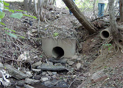
Figure 4a: Six storm drains empty urban runoff directly into the Teaneck Creek.
Click image to enlarge
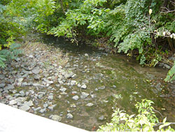
Figure 4b: During a storm event, the northern portion of Teaneck Creek adjacent to Fycke Lane exhibits "flashy" hydrology. Photos b and c were taken within 10 minutes of each other following an intense storm on September 29, 2005.
Click image to enlarge
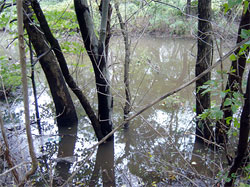
Figure 4c: During a storm event, the southern stretch experiences bank overflows. Photos b and c were taken within 10 minutes of each other following an intense storm on September 29, 2005.
The Teaneck Creek wetlands are situated adjacent to two major urban roadways (DeGraw Avenue on the southern boundary and Teaneck Road on the western boundary) at the northern terminus of the New Jersey turnpike (Interstate 95) and the eastern terminus of Interstate 80 (see Arnold and Berstrom et al. this volume for details of upstream conditions). South of the hospital, the creek flows under Teaneck Road, through the lawn of Thomas Jefferson Middle School, and under Fycke Lane, where it enters the wetland system. The stream bank on school property is in need of stabilization (Bergstrom et al. this volume) and is currently lined with the invasive plant Japanese knotweed (Polygonum cuspidatum), which is cut periodically by the school district and left to float downstream into the restoration site.
Site Characteristics
The topography of this system is characterized by a series of low-lying subwatersheds (Obropta et al. this volume), higher elevations due to the presence of various fill materials, a straightened creek channel with an adjacent clay fill berm that forms a levee, and, on the upland side of the berm, depressions with standing water containing monospecific stands of Phragmites australis (Figure 3). Teaneck Creek flows into Overpeck Creek, which is connected to the lower Hackensack River, a tidal estuarine system. The Teaneck Creek connection with the lower estuary has been altered due to the installation of tide gates seven miles south of the site. These gates close during incoming tides, and therefore the creek does not experience a typical tidal flushing. Twice daily, when the tide gates close, the waters flowing downstream are retained in the system until the tide changes and the gates reopen, creating a backwater effect that produces a daily tidal pulse (Obropta et al. this volume). When high tides coincide with precipitation events, it is common for the creek banks in the southern portion of the site to overflow (Figure 4c). Although Teaneck Creek is only 1.5 miles in length, the hydrology in the Fycke Lane northern section is completely different from that in the DeGraw Avenue southern section. During low-intensity storms, the Fycke Lane waters rise quickly, but this section only overtops the stream banks during major storm events. When a storm ends, the Fycke Lane stream waters quickly return to their low level (Figure 4b), resulting in a very "flashy" hydrograph for this portion of the creek.
Click image to enlarge
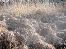
Figure 5a: Examples of Teaneck Creek vegetation: common reed (Phragmites australis) overgrown with porcelain berry (Ampelopsis brevipedunculata) and mile-a-minute vine (Polygonum perfoliatum).
Click image to enlarge
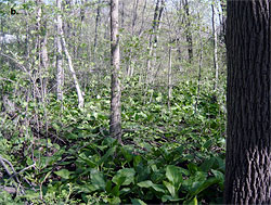
Figure 5b: Examples of Teaneck Creek vegetation: native forested wetland vegetation.
The hydrologic interface between Teaneck Creek, its tributaries, the groundwater, and the standing water depressions is unlike the connection found in a non-disturbed riparian corridor. In addition to two small tributary streams, there are six pipes that directly discharge stormwater from the Township of Teaneck into the wetland (Figure 4a). There are small groundwater seeps in some areas, but across most of the site the hydrologic connection between the groundwater and the creek has been eliminated due to the presence of underlying natural clay layers and clay fill dredge material (Obropta et al. this volume). In essence, much of the wetlands on this site appear to be functioning as perched bogs (Joan Ehrenfeld personal communication), dominated by precipitation and stormwater inputs.
The vegetation on the site (Ravit et al. this volume) is dominated by Phragmites australis, which is thriving in large, ponded areas that have formed in low-lying depressions. The newest invasive species to arrive in the system ca. 2005 is mile-a-minute vine (Polygonum perfoliatum), which now appears to be overpowering the Phragmites in certain sections (Figure 5a). In spite of the large areas covered by invasive monocultures, a forested wetland remains intact in the northeastern portion of the site (Steven Handel personal communication), where native wetland vegetation is thriving (Figure 5b). The hydric soils in this remnant area are continually saturated, and standing water is found here after a storm event. In spite of the site's invasive plant coverage (40% of the species observed covering approximately 40% of the site), total species diversity was found to be high (245 plant species).
Click image to enlarge
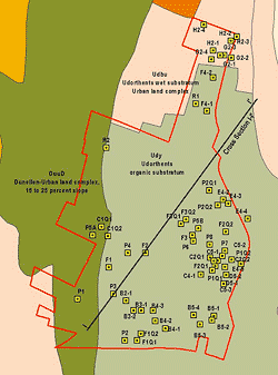
Figure 6: Teaneck Creek Conservancy site map showing 1999 soil test pit soil categorizations. (Note cross section I-I'.)
A site assessment was completed for Bergen County in 1999. As part of this assessment, soil samples were collected from test pits throughout the site, and the soils were classified as Udorthents (Figure 6). No soil profile was observed in these soil borings, and the only hydric soils were located in the forested northeastern corner of the site adjacent to Fycke Lane. A cross section detailing the site soils (Figure 7) shows the presence of sand and clay fill material above the organic mat. However, patches of various substrates are scattered throughout the 46 acres, and include: 1) unconsolidated fill materials; 2) clay dredge sediments placed on the site as fill; 3) reduced organic wetland soils; and 4) in the northern portion of the stream bank, sand (Figure 8). In addition, there is a large area on the southern border of the site adjacent to DeGraw Avenue where construction debris, including asphalt and concrete, and discarded large household items have been dumped illegally (Figure 9). The wetland delineation completed in 2006 (Figure 10) shows that the majority of the site has been classified as wetland.
Baseline Site Characterization
Click image to enlarge
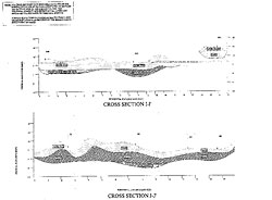
Figure 7: Teaneck Creek Conservancy 1999 soil test pit cross section showing substrate materials.
To ensure a sustainable wetland restoration, the Interstate Technology Regulatory Council (ITRC 2005) recommends a thorough assessment of the wetlands being restored to "understand the hydrology, soil, and plants, and how they interact to affect the functions or values provided by the wetlands." This is a factor in the decision by the New Jersey Wetlands Mitigation Council (NJWMC) to fund a scientific baseline assessment prior to development of the Conceptual Restoration Plan, in the hopes that the Teaneck Creek restoration would not be another freshwater riparian wetland failure. During the three-year study, the Conservancy site has been characterized with respect to:
- Surface water inputs, hydrologic flow rates, and nutrient loadings;
- Groundwater depths to water table, flow rates, and nutrient loadings;
- Presence, abundance, and location of native and invasive vegetation;
- Soil characteristics associated with various hydrologic regimes on the site; and
- Sediment denitrification potential pre-restoration.
Click image to enlarge
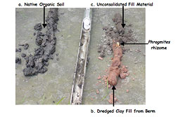
Figure 8: Soil cores obtained from: a) undisturbed location with native wetland vegetation and hydric soils; b) and c) from an area vegetated with monospecific stands of common reed (Phragmites australis).
These activities have been coordinated through the Rutgers Environmental Research Clinic (www.rerc.rutgers.edu). Rutgers University has also contracted with the U.S. Geological Servey (USGS) to train students in accepted hydrologic sampling techniques. Stormwater samples have been collected quarterly over the last two years and analyzed in the USGS laboratories (Obropta et al. this volume). Shallow groundwater monitoring wells, reaching a depth of 40 cm below the soil surface, were installed at 30 locations within the TCC site (Figure 10). To install these wells, a soil core was excavated using a hand auger, and a PVC shallow groundwater well containing screened holes to allow water movement into the well was placed in the hole. The excavated area remaining around the well was filled with sand; the sand and the adjacent soil surface were then capped with bentonite clay to preclude movement of water into the well from the surface, and the well was capped. Hydrology data has now been collected for over a year at each well by measuring depths of inundation and depths to groundwater on a weekly basis.
Click image to enlarge
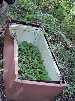
Figure 9: Discarded refrigerator debris serves as "natural" planter for garlic mustard (Alliaria petiolata) on Conservancy site.
Analysis of soil samples was conducted to determine moisture content, nutrients, conductivity, pH, and micronutrients. These samples were collected at the locations where groundwater wells were installed, prior to placement of the wells (Figure 10). Samples were obtained using a corer 25 cm in length and 10 cm in diameter. Results of these analyses indicate a high degree of heterogeneity related to the hydrology and the amount and type of fill material present at each sampling location. Soil organic carbon proportions ranged from 2% to 22%, TKN values ranged from 0.08% to 0.57%, and ammonia concentrations ranged from 0.1 to 11.0 ppm. Soil pH varied from 6 to 7.85, and we hypothesize that the high end of this range is due to the decomposition of concrete debris. The soil categories range from clay to sandy loam. In addition to the clay fill material forming the creek bank berms, there are natural clay layers and lenses under most of the site at depths varying from 1 to 4 feet.
A vegetation analysis was also completed (Ravit et al. this volume). The site was organized into a series of 32 grids, and each grid was surveyed to determine the presence or absence and the abundance of both native and invasive vegetation. Plant Stewardship (PSI) and Floristic Indices (FI) were subsequently calculated for each grid. Data related to the plant species, depths to the water table, and soil properties are now being analyzed to determine which native plants might be sustainable in the different subwatersheds of the site, given the various combinations of hydrology and soils.
Click image to enlarge
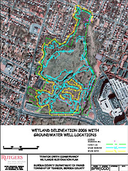
Figure 10: Teaneck Creek Conservancy site map showing the wetland delineation completed in 2006. Circles indicate location of shallow groundwater wells and soil sampling locations.
Because nitrogen (N) leaving this system can contribute to high rates of eutrophication in the lower Hackensack River estuary, we chose to target a decrease in N transport out of the system as a functional restoration goal. Denitrification rates are now being analyzed in soil samples taken from multiple locations on the site (Figure 10), and these rates will be used to calculate changes in denitrification potential of the Conservancy wetlands pre- and post-restoration. We also undertook a study to characterize the contribution of atmospheric deposition of carbon and nitrogen loadings to the site (Ravit et al. 2006). Samples were collected quarterly during 2005–2006 and analyzed for wet and dry deposition of organic and inorganic (nitrate, ammonia) N compounds. Wet deposition of inorganic N was ten times greater than dry deposition, and the range of nutrient concentrations measured was similar to the regional signals found for the New York–New Jersey region by Lovett et al. (2000), Meyers et al. (2001), and Seitzinger et al. (2005). When dry particle N deposition was compared in samples taken at various distances from the DeGraw Avenue roadway, inorganic N concentrations found at the roadside were 20–50% higher than 100 meters away from the road.
Click image to enlarge
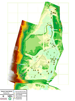
Figure 11: Map of all sampling locations.
To achieve our goal of 20 acres of rehabilitated wetlands, there must be an increase in flooding and a subsequent retention of water by additional acreage within the TCC site. To achieve increased wetland acreage, changes must occur in the topography of the system, and these changes will take into account removal of debris, the water flow patterns of the six stormwater inputs, the inter subbasin water movements, and surface flows from the Teaneck Creek. The results of the baseline studies are being incorporated into a Conceptual Restoration Plan for the TCC site, which will include detailed grading plans, planting plans, and invasive species control plans. A secondary long-term project goal is to develop an Urban Wetland Model capable of describing the relationship between hydrology, vegetation, and soil denitrification within this urban wetland system.
Acknowledgments
Funding support for the Teaneck Creek studies has been provided by the New Jersey Wetlands Mitigation Council and the New Jersey Water Resources Research Institute. Maps are courtesy of Sean Walsh and Michael Mak (Rutgers University) and Jeremiah Bergstrom (TRC Omni Environmental). We gratefully acknowledge the unwavering support by the Teaneck Creek Conservancy staff for all the project scientists, students, and volunteers.